
NJ Weather Snowstorm Could Dump 12 to 18 Inches With Dangerous Ice
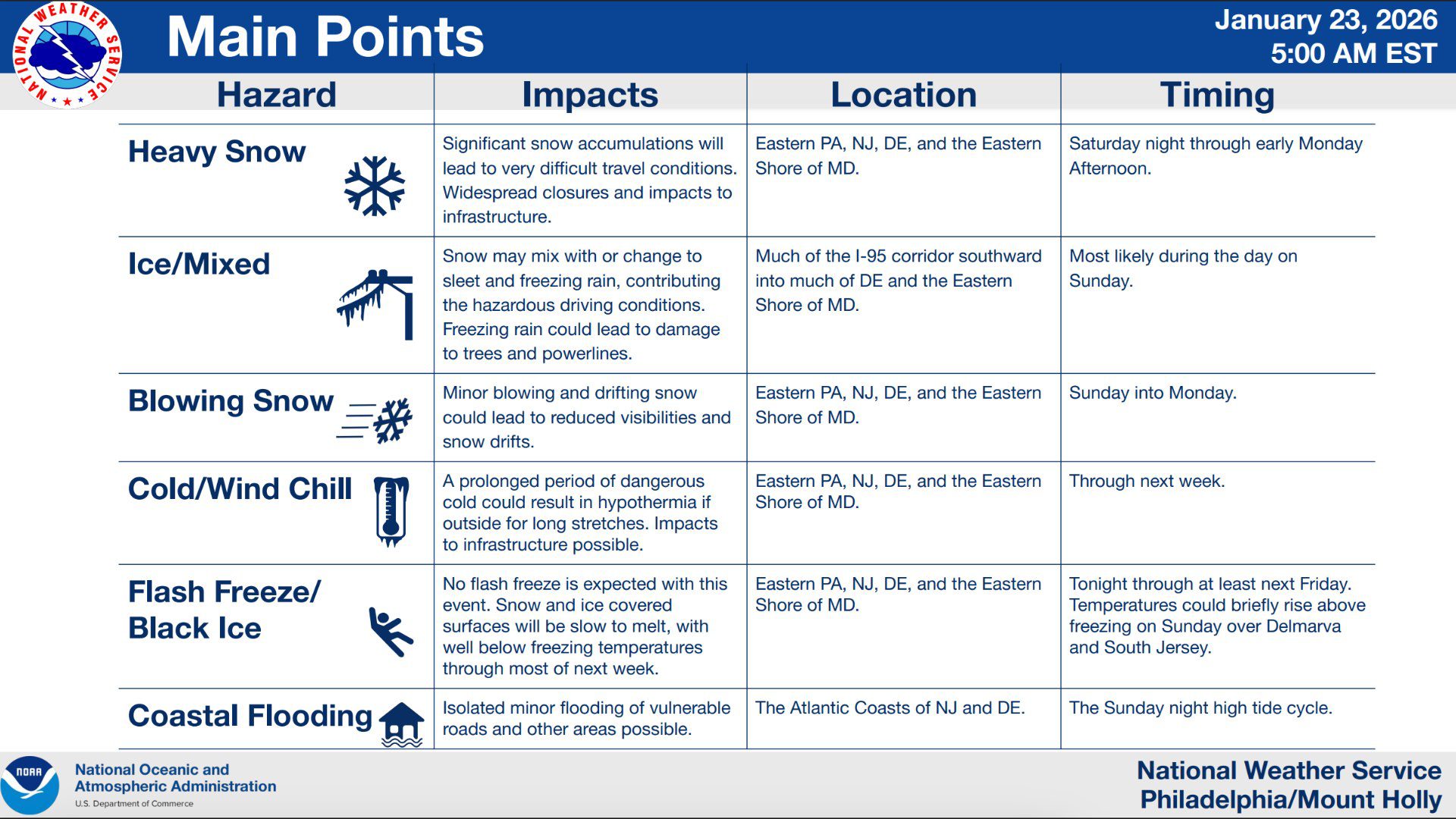
A significant winter storm is expected to impact Philadelphia, South Jersey, and the surrounding region beginning Saturday night and continuing through early Monday afternoon. The National Weather Service Philadelphia Mount Holly office says confidence continues to increase that this system will bring major snowfall, ice, dangerous travel conditions, and a prolonged period of extreme cold across eastern Pennsylvania and New Jersey
A Winter Storm Watch remains in effect for the entire region from 7 PM Saturday through 1 PM Monday. Forecasters warn that this will likely be a high impact event for both urban and suburban areas, including the Philadelphia metro area and much of South Jersey.
NJ Weather Snowstorm Could Dump 12 to 18 Inches With Dangerous Ice
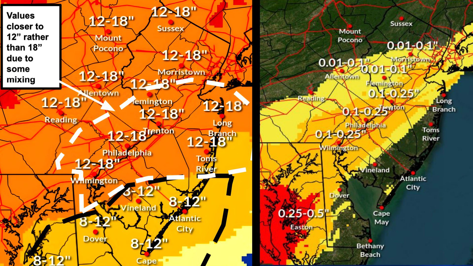
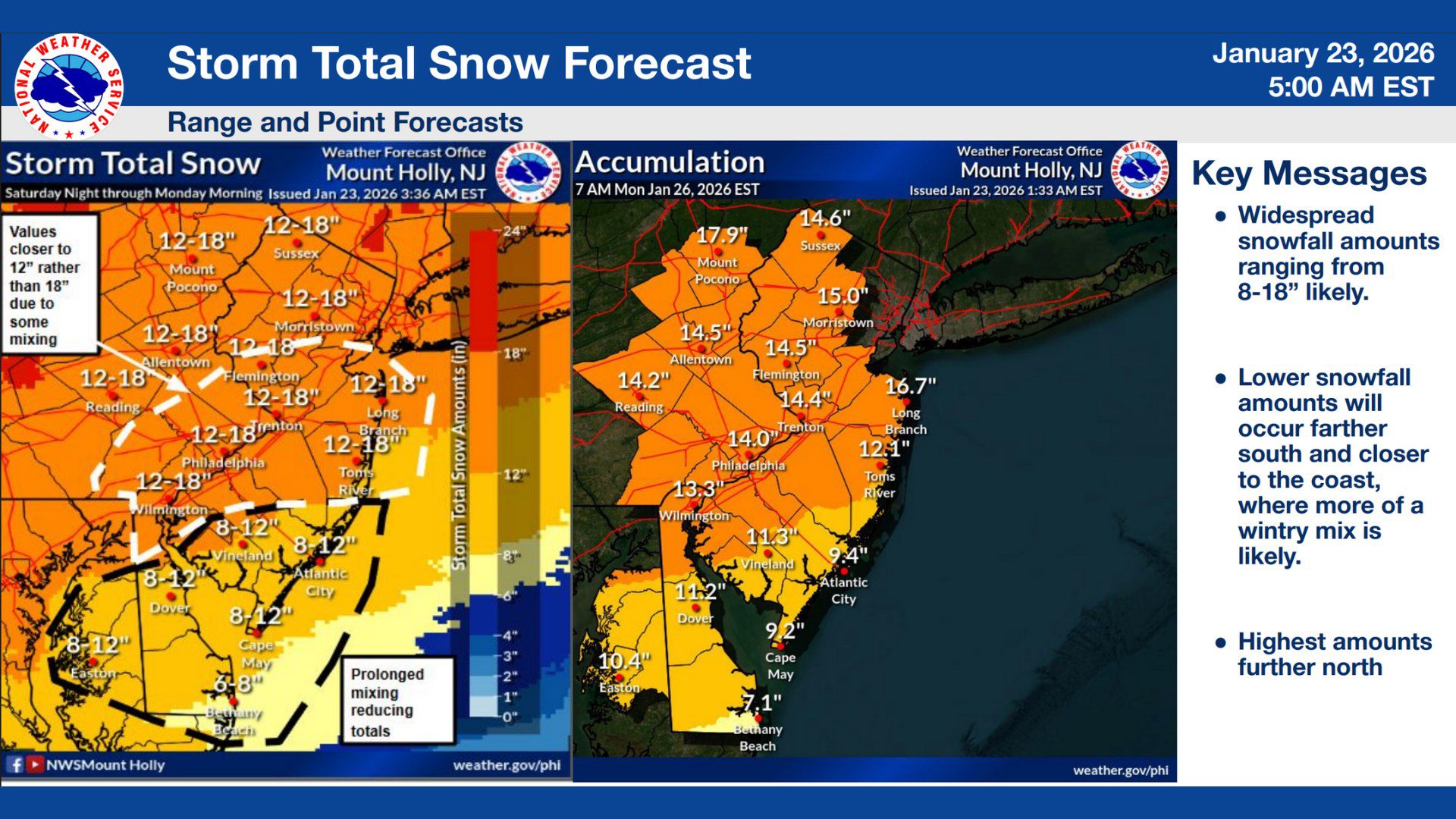
Snowfall Forecast for Philadelphia and the I 95 Corridor
For Philadelphia and nearby communities along the I 95 corridor, snowfall totals are currently projected to range between 12 and 18 inches. However, forecasters caution that periods of sleet or freezing rain could mix in at times, potentially reducing totals closer to the lower end of that range. Even with some mixing, significant accumulation is expected, enough to severely impact travel and daily life
Snow is expected to become heavy at times late Saturday night into Sunday, with snowfall rates capable of overwhelming plowing and treatment efforts. Travel on major roadways including I 95, I 76, and the Pennsylvania Turnpike could become extremely difficult or impossible during the height of the storm.
 What South Jersey Can Expect
Across South Jersey, including Camden, Gloucester, Burlington, Atlantic, and Cape May counties, snowfall totals are expected to be slightly lower overall due to warmer air pushing in from the south and east. Current forecasts call for 8 to 12 inches of snow for much of the region, with lower amounts closer to the coast.
Despite lower snowfall totals, South Jersey may face some of the most dangerous conditions due to an increased risk of sleet and freezing rain, especially on Sunday. The National Weather Service says mixing will be more prolonged in these areas, which could lead to icy roadways and hazardous travel even where snow totals are reduced
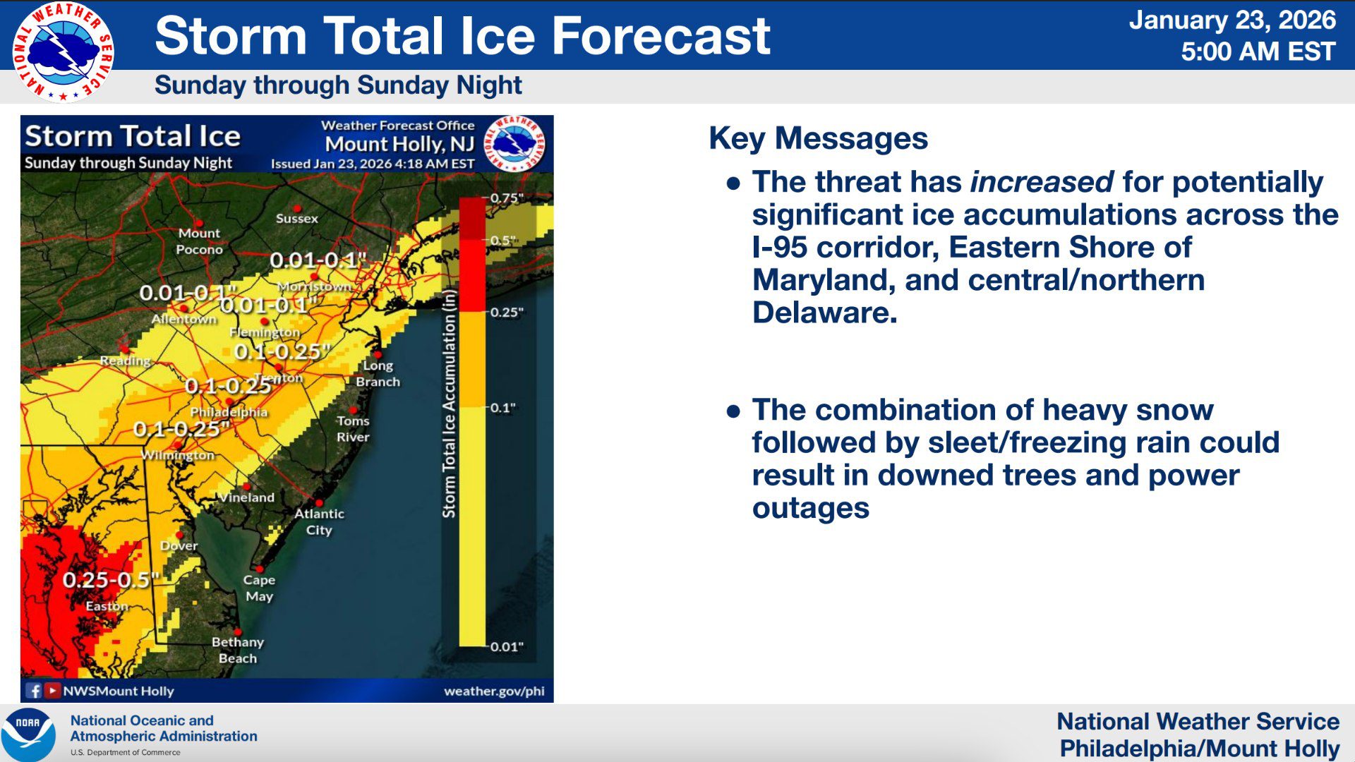 Growing Ice Threat Raises Power Outage Concerns
One of the most concerning aspects of this storm is the rising potential for ice accumulation, particularly along and south of the I 95 corridor. Forecasts indicate that portions of Philadelphia, South Jersey, Delaware, and the Eastern Shore could see ice accumulations between one tenth and one quarter of an inch.
That level of ice is enough to weigh down trees and power lines, increasing the risk of scattered power outages. The combination of heavy snow followed by freezing rain could significantly complicate cleanup efforts and emergency response
 Travel Conditions Likely to Become Dangerous or Impossible
The National Weather Service warns that heavy snow and ice will likely make travel dangerous or impossible at times. Widespread road closures, flight delays, and cancellations are possible from Saturday night through Monday. Blowing and drifting snow on Sunday into Monday could further reduce visibility and lead to rapidly changing road conditions across the region
Officials strongly advise residents to avoid unnecessary travel during the storm and to complete all preparations before Saturday evening.
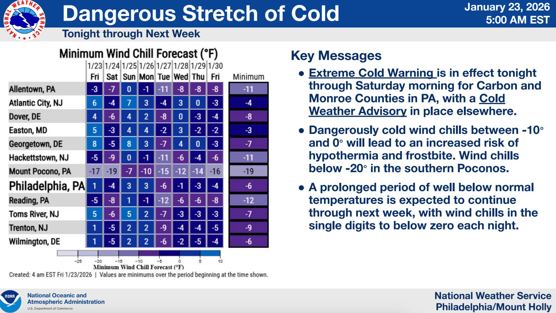
Dangerous Cold to Linger Into Next Week
Adding to the storm’s impact is a prolonged stretch of dangerous cold beginning Friday night and continuing well into next week. While the most extreme conditions will be felt in the southern Poconos, wind chills across Philadelphia and South Jersey are expected to drop into the single digits and below zero during overnight periods.
The National Weather Service warns that prolonged exposure to these temperatures can lead to frostbite and hypothermia in a short amount of time. Snow and ice covered surfaces will also be slow to melt due to sustained below freezing temperatures, extending travel hazards beyond the end of the storm
 What Residents Should Do Now
Residents across Philadelphia and South Jersey are urged to prepare now by limiting travel plans, charging electronic devices, stocking emergency supplies, and checking on elderly or vulnerable neighbors. Those with marine interests should also be aware that a Freezing Spray Advisory is in effect for coastal waters.
Forecasters stress that this forecast is time sensitive, and updates will continue as the storm approaches. Another official briefing is expected later today with refined details on snowfall and ice potential.
PLEASE do not be stupid this weekend. Stay home and do not go outside unless you have to!!!