The National Weather Service in Mount Holly put out their latest briefing and so we are going to break it down for you. In simple terms it says that snow amounts increased over northern half of New Jersey.
New Jersey Nor’Easter Update – Snow Totals
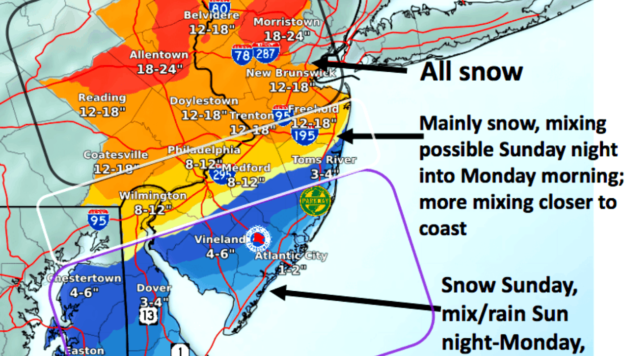
Precipitation will begin as snow as it arrives SW to NE Sunday afternoon and evening(The South will get it before the North). Sunday night into Monday morning, a mix with or change to sleet and rain is likely from the coast up to near the I-95 corridor. Precipitation changes back to snow by late Monday before winding down Tuesday afternoon.
Snow Totals
Significant snowfall is expected, with the heaviest amounts favored over eastern Pennsylvania and central and northern New Jersey.The expected area of heaviest snow has shifted northward today. (Think Morristown NJ and Allentown PA).
The exact storm track remains uncertain and a shift in track could bring the heavier snow amounts farther north or south. The heaviest snow is likely during the day Monday, when rates could exceed 1 inch per hour in the heaviest bands. Snow will likely continue into Tuesday, but additional accumulation then will be limited.
Looking at the chart Philadelphia will get 8-12 inches with Cape May County getting 1-2 inches. The most of the snow fall will take place near Morristown NJ with 18-24 inches. The towns just south of Morristown, New Brunswick and Trenton, could get 12-18 inches.
Winds
Strong winds will develop especially near the coast and over the waters with gusts reaching 40 to 50+ mph, strongest on Monday, resulting in hazardous boating conditions and potential power outages.
Inland, gusts could reach 35 to 45 mph, resulting in reduced visibility and very hazardous travel in blowing and drifting snow.
Flooding
Coastal flooding is likely and could reach moderate levels as early as Monday morning along the Atlantic coast and Delaware Bay with additional coastal flooding possible Monday afternoon and Tuesday morning.
Tune back later today for another update (around 5pm).