
New Jersey Snow Forecast Explodes With 24 Inch Threat
Forecast confidence has reached its highest level yet as the National Weather Service continues to upgrade alerts ahead of a powerful winter storm expected to impact New Jersey and the surrounding region from Sunday into Monday.
Blizzard Warnings and Winter Storm Warnings have expanded across the area as meteorologists warn of escalating impacts from heavy snowfall, strong winds, and coastal flooding. Marine alerts have also intensified, with Storm Warnings now in effect for all Atlantic coastal waters and the lower Delaware Bay, while a Gale Warning remains in place for the upper Delaware Bay.
In addition, Coastal Flood Watches have been upgraded to Coastal Flood Warnings for tidal communities along Atlantic coastal New Jersey, including Middlesex, Monmouth, Ocean, southeastern Burlington, Atlantic, and Cape May counties.
New Jersey Snow Forecast Explodes With 24 Inch Threat
Updated Snowfall Forecast Shows Higher Totals
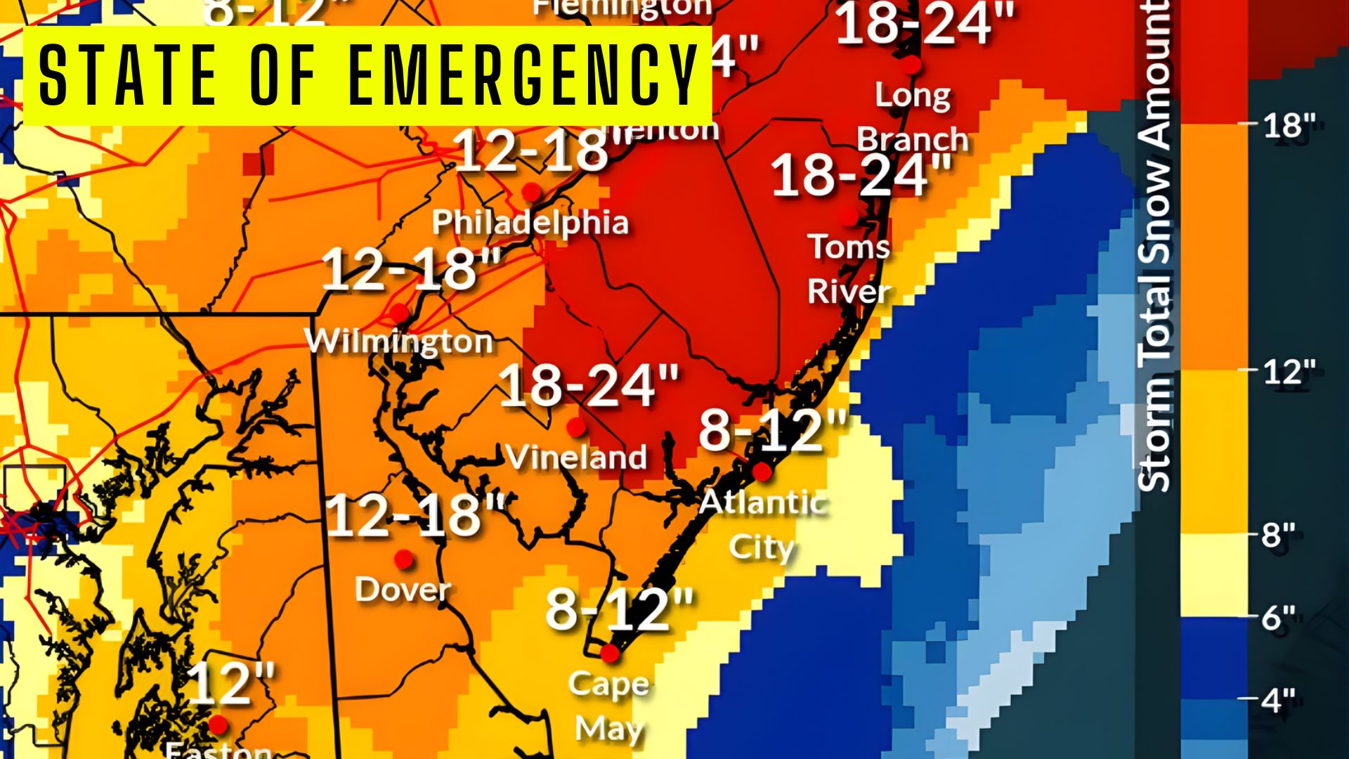
The latest snowfall projections show totals continuing to climb across much of New Jersey, with a pronounced jackpot zone emerging across central portions of the state.
The highest snowfall amounts of 18 to 24 inches are now forecast across central New Jersey, including Ocean County near Toms River, Monmouth County including Long Branch, Mercer County around Trenton, and parts of inland central New Jersey extending toward Flemington. Portions of interior southern New Jersey may also see localized totals within this range due to strong banding.
A broader swath of 12 to 18 inches is expected across northern New Jersey, the Philadelphia metro region, inland South Jersey including Vineland and interior Atlantic County, as well as northern Delaware and southeastern Pennsylvania.
Coastal barrier island communities, including Atlantic City and Cape May, are forecast to receive slightly lower but still significant totals of 8 to 12 inches, where early mixing and marine influence may limit peak accumulations.
Meteorologists say the updated snowfall map highlights a classic coastal storm structure, with strong mesoscale banding driving extreme totals across central New Jersey while coastal mixing trims accumulations along the immediate shoreline.
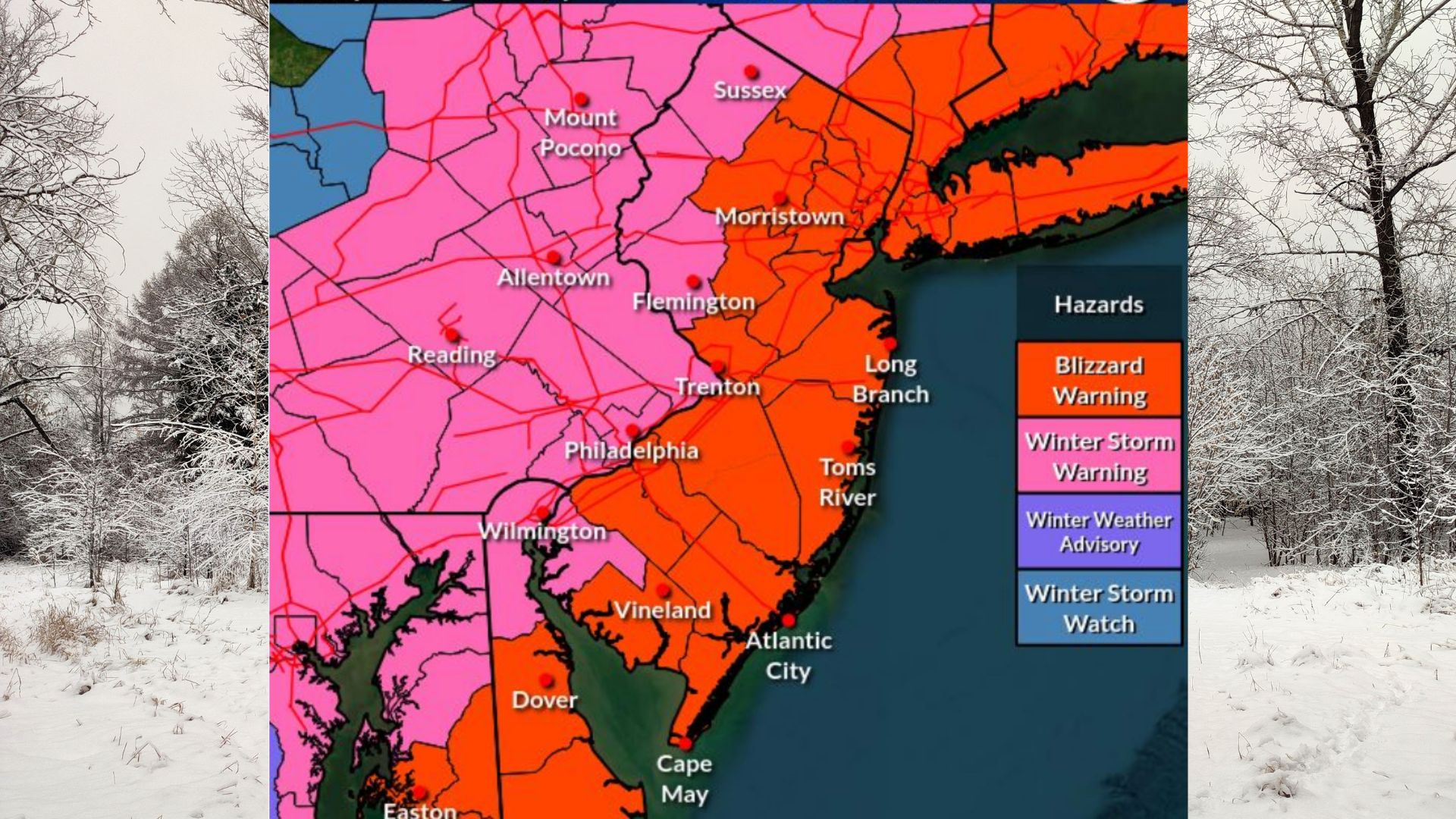
 Blizzard Conditions Expected Across Coastal New Jersey
Forecasters warn that blizzard conditions will develop across areas along and southeast of the I-95 corridor, bringing extremely dangerous travel conditions and near whiteout visibility at times.
Snowfall rates of two inches per hour or greater are likely during the storm’s peak Sunday night into Monday morning. Combined with wind gusts up to 55 mph along the coast, this will produce widespread blowing and drifting snow and could lead to extensive closures and infrastructure impacts.
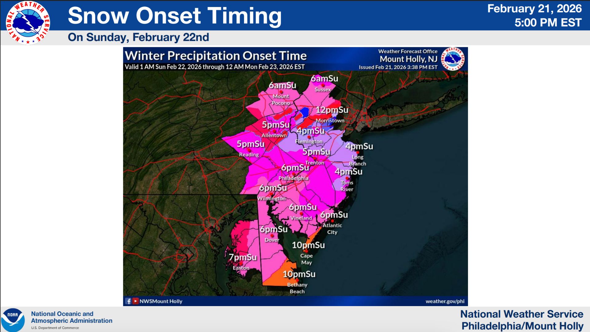
Snow is expected to begin as early as Sunday morning and continue through Monday afternoon, with the heaviest snowfall focused overnight into Monday morning.
 Heavy Snowfall Inland
Areas under Winter Storm Warnings, including extreme northwest New Jersey, eastern Pennsylvania, northeastern Maryland, and northern Delaware, are expected to experience heavy snow and difficult travel conditions. Winds gusting up to 40 mph may still produce blowing snow and reduced visibility inland.
The heaviest snow accumulations remain focused across New Jersey and adjacent portions of southeastern Pennsylvania and northern Delaware, with the storm expected to impact both the Monday morning and evening commutes.
Also See: Navy Special Ops Boats Spotted In Jersey Back Bays

 Storm Timing and Precipitation Type
Precipitation will likely begin Sunday morning and continue into Monday morning before tapering off Monday afternoon. Forecasters say the storm may start as rain near and south of I-78, with a transition to snow occurring late Sunday morning into the afternoon. Areas north of I-78 are expected to remain all snow.
Strong Winds and Power Outage Risk
Northeast winds will increase Sunday and persist through Monday, with the strongest winds expected Sunday night into Monday morning. Coastal gusts may reach 55 mph, while inland gusts could approach 40 mph. These winds may cause localized tree damage and scattered power outages.
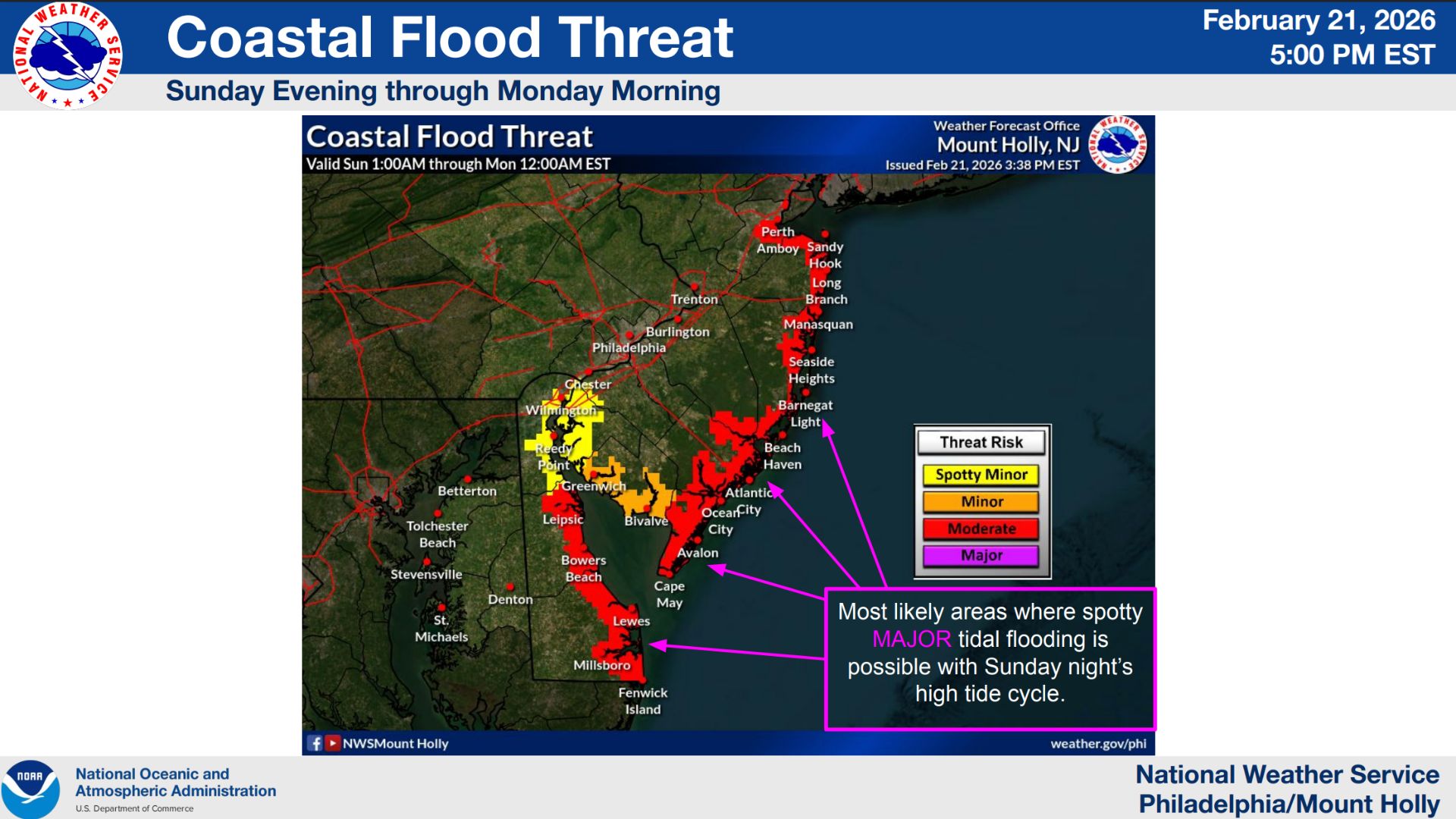 Coastal Flooding Threat Escalates
Coastal Flood Warnings now in effect highlight increasing concern for flooding along the Jersey Shore and Delaware coastline. Minor to moderate flooding is likely, with spotty major flooding possible, especially during Sunday night’s high tide cycle.
Forecasters say one to two feet of inundation above ground level is possible in vulnerable low-lying areas near shorelines and tidal waterways. Widespread roadway flooding is expected in coastal and bayside communities, with some roads potentially becoming impassable and minor structural damage possible.
Additional minor flooding may persist into Monday with subsequent high tide cycles.