
Winter Storm Warning for the Tri-State – Details
A powerful winter storm is set to impact the region this weekend, bringing a mix of snow, freezing rain, and dangerously cold temperatures.
The storm will begin Saturday morning and continue into early next week, with significant impacts on travel, infrastructure, and safety. Here’s what you need to know.
Winter Storm Warning for the Tri-State – Details
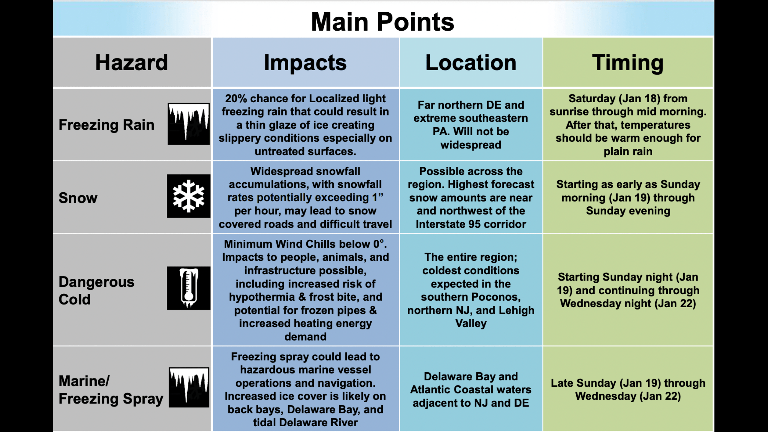
Saturday Morning: Freezing Rain Threat
The storm will begin with a low chance (20%) of localized freezing rain in far northern Delaware and extreme southeastern Pennsylvania. This light, patchy precipitation is expected from sunrise through mid-morning and may create a thin glaze of ice on untreated surfaces, leading to slippery conditions. While not a widespread issue, residents in these areas should use caution when traveling or walking outdoors.
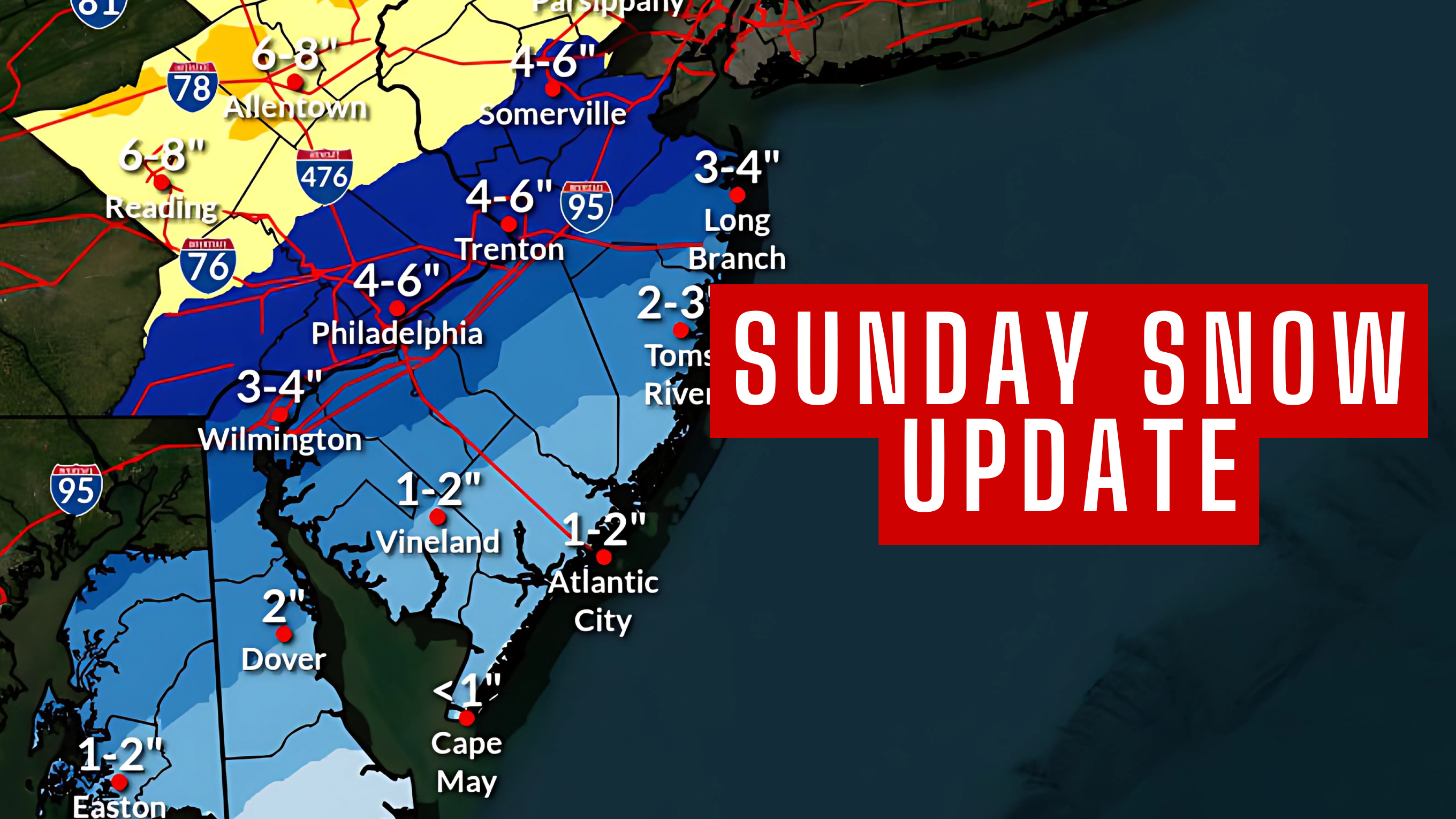
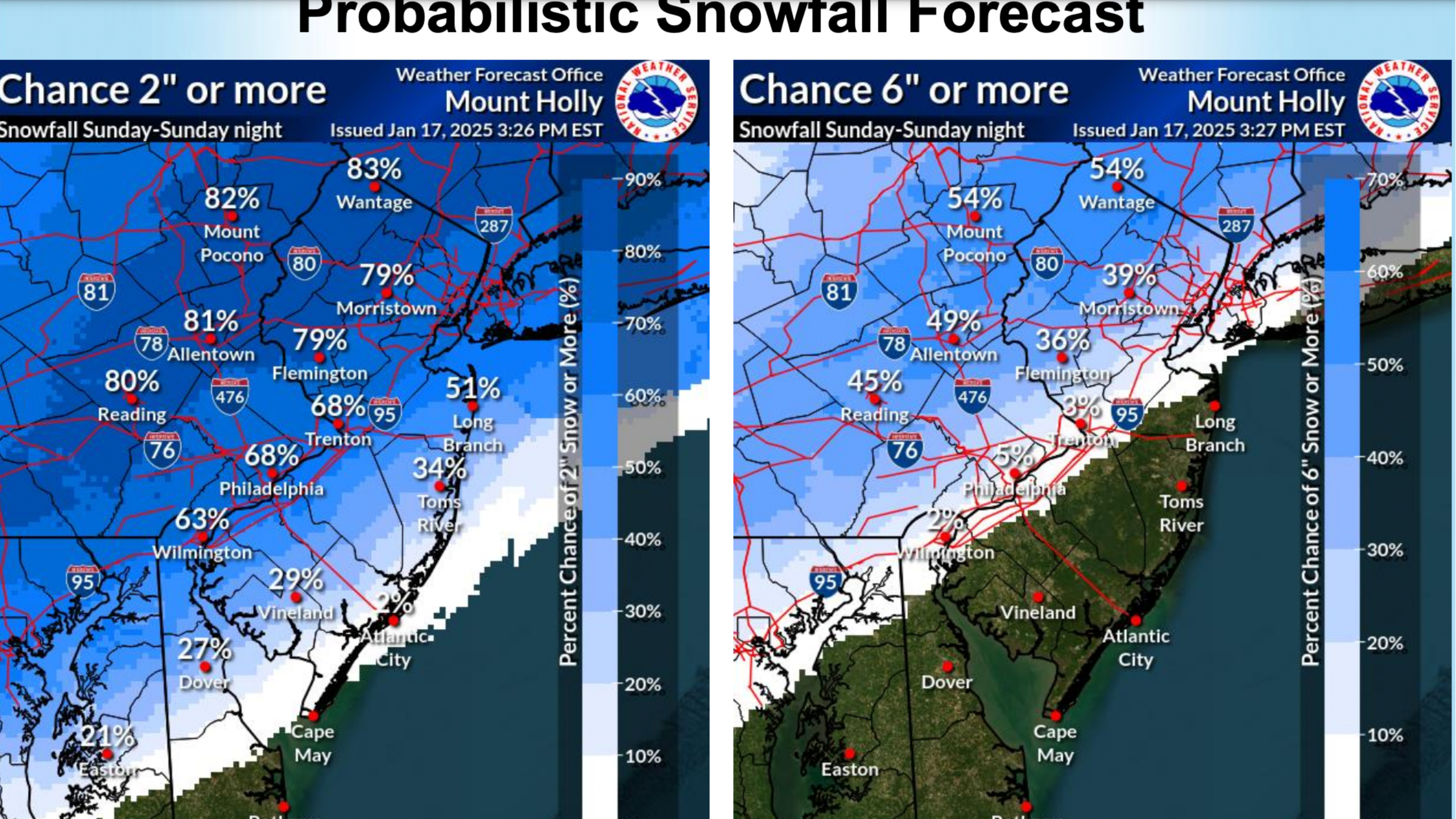
 Sunday: Heavy Snow and Coastal Rain-Snow Mix
Sunday will bring the storm’s most significant impacts, as widespread snow blankets the region.
- Inland Areas: Communities northwest of the I-95 corridor are expected to bear the brunt of the storm, with snowfall totals of 6 to 10 inches. During the height of the storm, snowfall rates could exceed 1 inch per hour, creating treacherous travel conditions and rapidly covering roads.
- Coastal Areas: Closer to the coast, warmer air will cause snow to mix with rain, resulting in 1 to 3 inches of accumulation.
 Timing of the Storm:
- Morning (8 AM – Noon): The first flakes arrive, with rain potentially mixing in during the early stages.
- Afternoon to Evening (2 PM – 8 PM): The heaviest snow will fall, with intense precipitation rates and rapid accumulations.
- Evening (9 PM – 11 PM): The storm will taper off and exit the region, leaving snow-covered roads in its wake.
Also See: Steven Spielberg To Film UFO Film in Cape May – Extras Needed
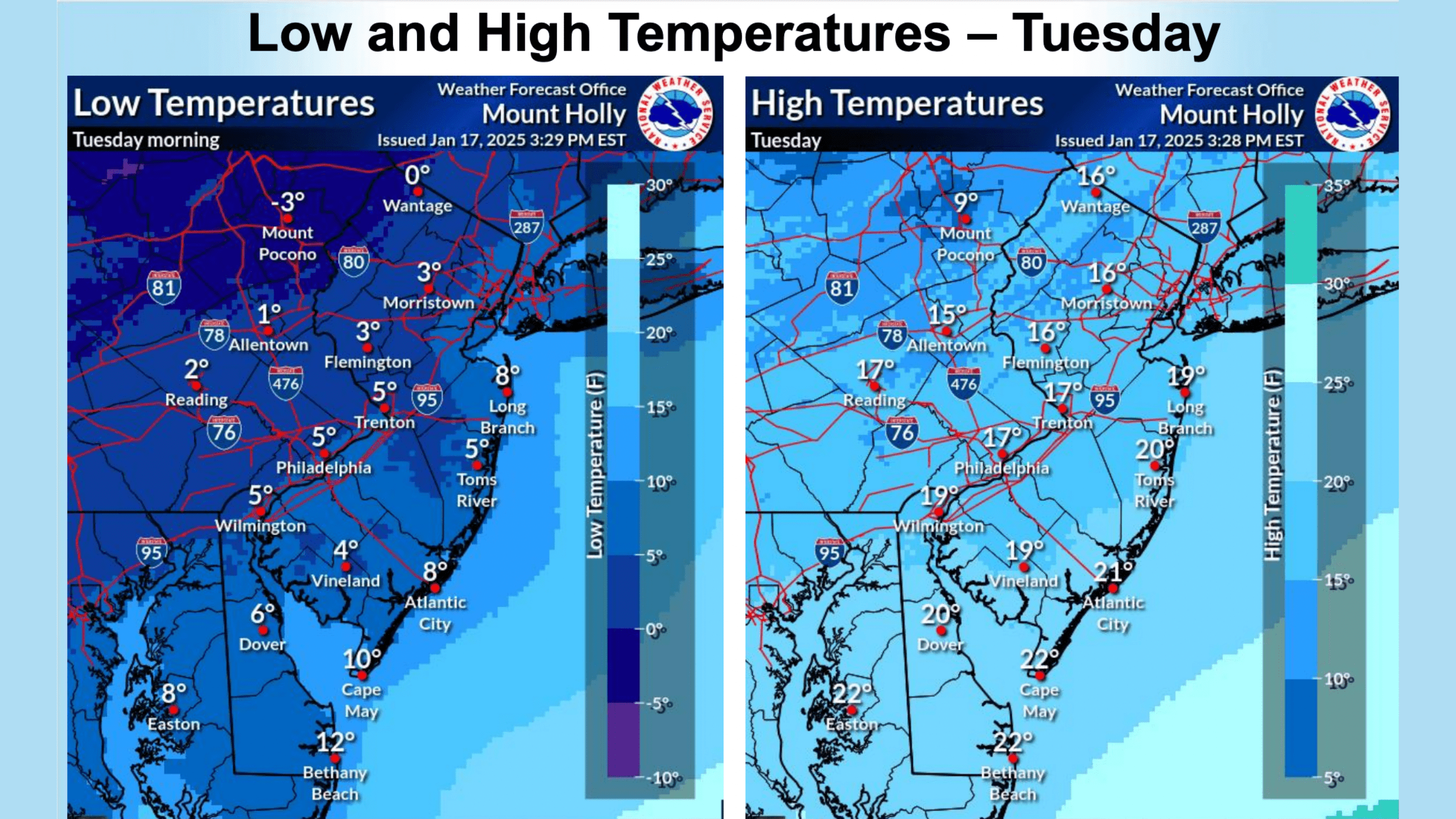
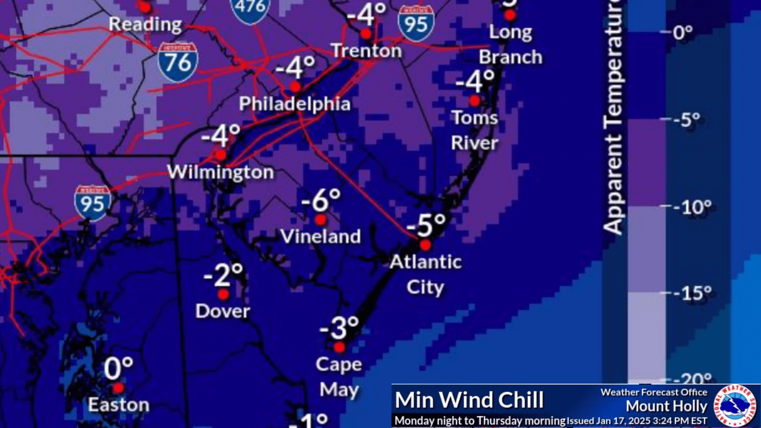
 Sunday Night Through Wednesday: Life-Threatening Cold
As the storm departs, Arctic air will surge into the region, bringing dangerously cold temperatures and wind chills below 0°F. These frigid conditions will linger from Sunday night through Wednesday, posing serious risks to people, animals, and infrastructure.
- Human and Animal Safety: Prolonged exposure to these temperatures increases the risk of hypothermia and frostbite. Limit time outdoors, wear proper winter clothing, and check on vulnerable individuals.
- Infrastructure Concerns: The extreme cold may lead to frozen pipes, higher heating demands, and increased energy usage. Residents should prepare by insulating pipes and ensuring adequate heating supplies.
The coldest areas will include the southern Poconos, northern New Jersey, and Lehigh Valley, but the entire region will experience significant impacts.
 Marine and Ice Hazards
The storm will also affect marine operations and waterways:
- Freezing Spray: Open waters in Delaware Bay and along New Jersey’s Atlantic coast will experience freezing spray, creating hazardous conditions for vessels.
- Ice Formation: Ice cover will increase on back bays, Delaware Bay, and the tidal Delaware River, further complicating navigation. Mariners are urged to avoid operating in these areas until conditions improve.
Preparing for the Storm
Residents should take action now to prepare for the storm’s impacts.
- Ensure you have adequate heating supplies and protect pipes from freezing.
- Avoid unnecessary travel during the height of the storm, especially in areas expecting heavy snow.
- Protect pets and livestock from the cold and ensure they have access to shelter and water.
Stay informed by monitoring local weather forecasts and emergency alerts, and take all necessary precautions to stay safe during this significant winter storm.
With snow, ice, and bitter cold on the way, it’s essential to plan ahead and stay prepared for challenging conditions over the coming days.