
NOR’EASTER TOBY UPDATE (6:30pm)
Here is the latest update on Nor’Easter Tobyaccording to National Weather Service.
-
Elevated travel impacts due to a light wintry mix expected into tonight.
-
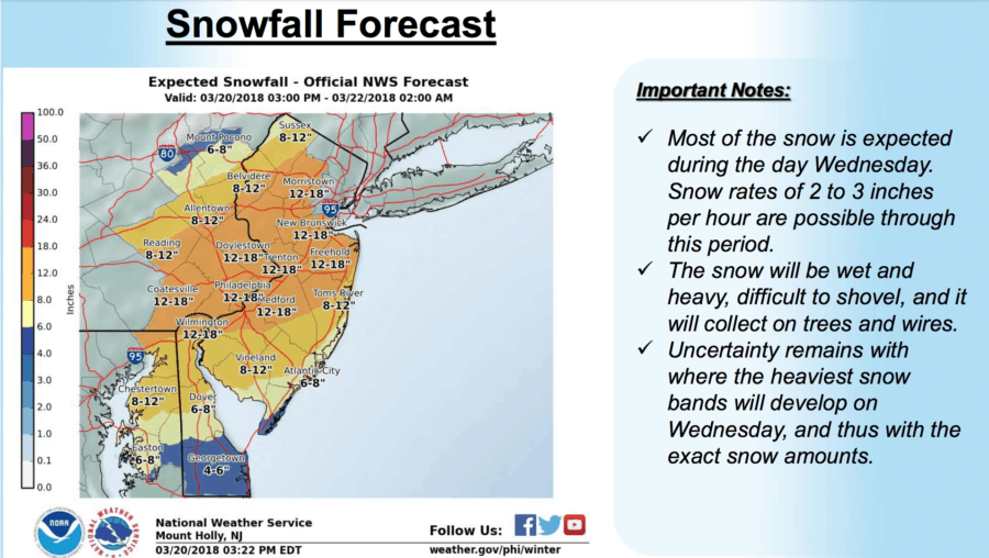
Heavy snow and significant impacts are expected during the day Wednesday into Wednesday evening. Snowfall rates of 2 to 3 inches per hour and thunder will be possible on Wednesday. Travel is not recommended.
-
This will be a heavy, wet snow which will be difficult to shovel and will stick to trees and power lines. This, combined with the strong winds, could lead to power outages and tree damage.
-
Coastal flooding will be a concern through the next three high tide cycles. Minor coastal flooding is expected tonight. Minor to moderate coastal flooding is expected with the high tide cycles Wednesday and Wednesday night.
-
Storm force winds and rough seas on the coastal waters of NJ and DE, and on Delaware Bay from into Wednesday.
Here are what the projected snow totals look like
A Winter Storm Warning means significant amounts of snow, sleetand ice will make travel very hazardous or impossible. The latestroad conditions for the state you are calling from can beobtained by calling 5 1 1.
https://wildwoodvideoarchive.com/moreys-piers-in-the-snow-drone/