
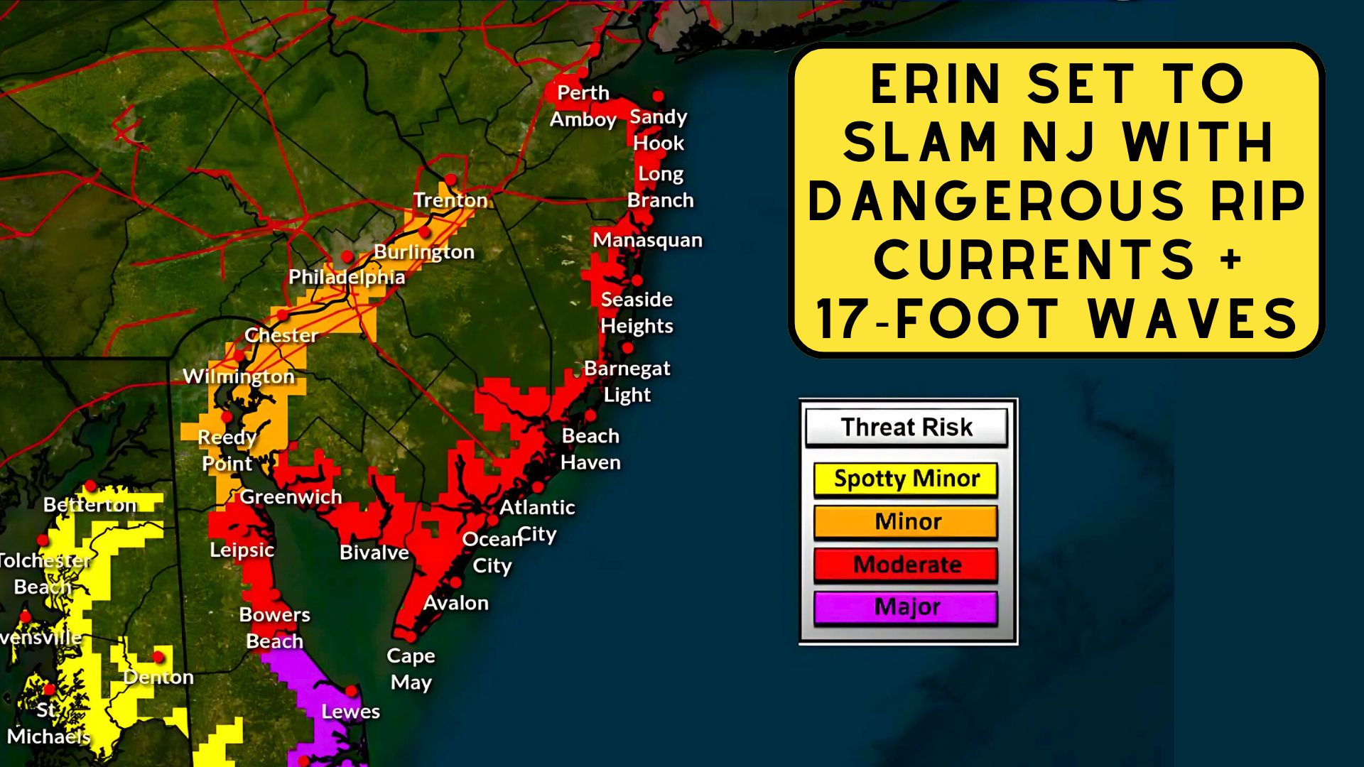
Hurricane Erin Set to Slam NJ With Dangerous Rip Currents and 17-Foot Waves
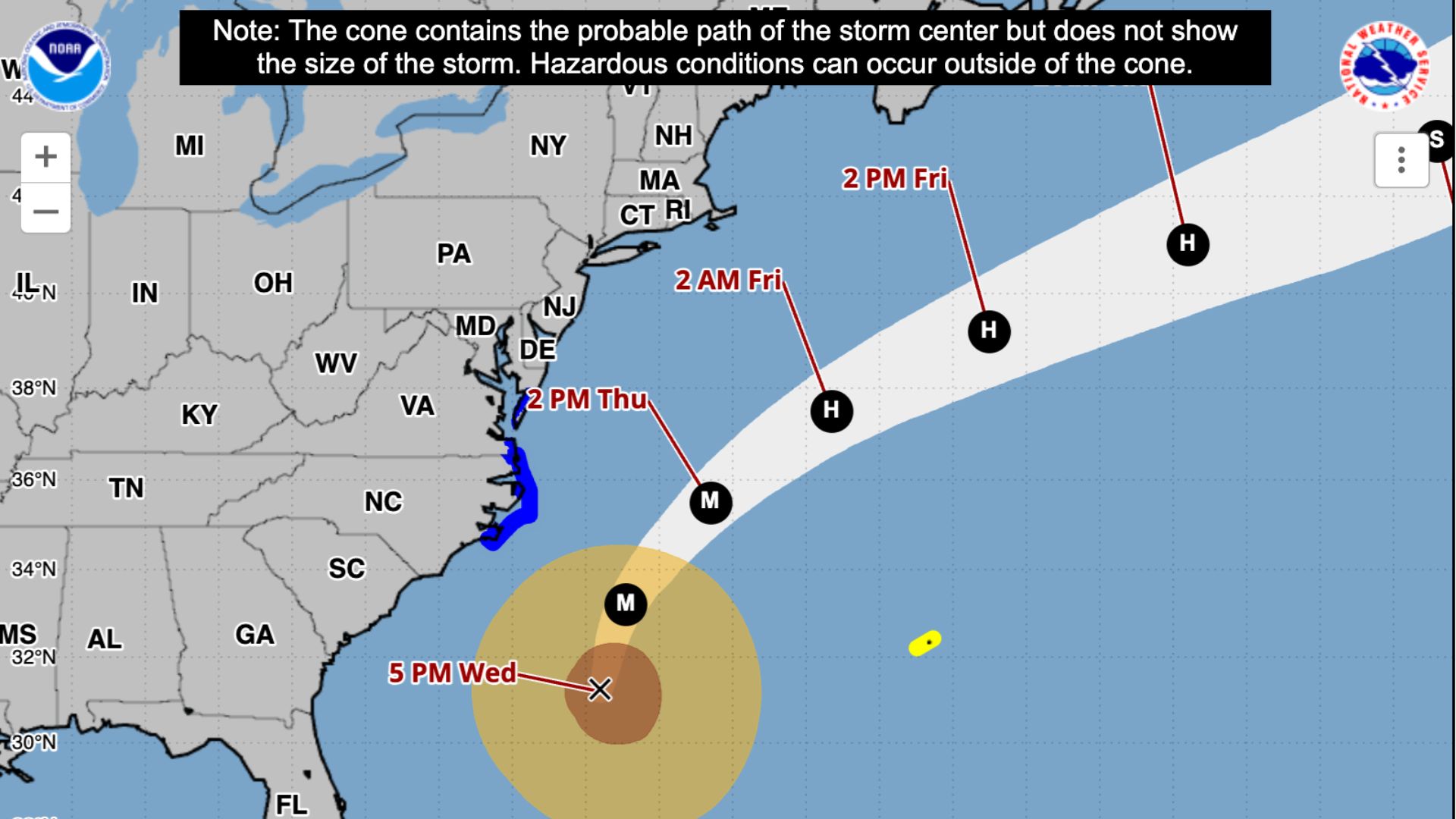
The National Weather Service in Mount Holly is warning of widespread coastal impacts as Hurricane Erin passes well offshore later this week, with forecasters cautioning that the storm’s large wind field will drive dangerous seas, flooding, and beach erosion from Thursday into Friday.
Hurricane Erin Set to Slam NJ With Dangerous Rip Currents and 17-Foot Waves
While the center of Erin will remain southeast of the mid-Atlantic coast, its closest approach is expected late Thursday, bringing sustained northeast winds of 25 to 35 miles per hour along the coasts of New Jersey and Delaware, with gusts as high as 50 m.p.h.
A Wind Advisory has been issued for the shoreline communities, while inland areas may see gusts between 20 and 30 m.p.h.
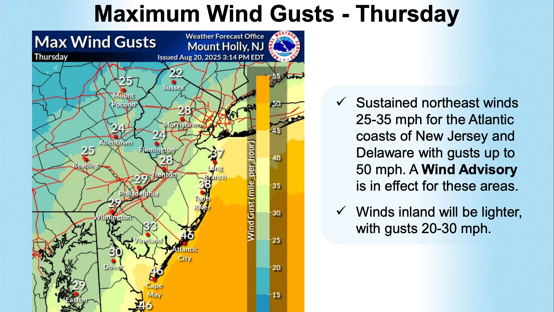 The combination of strong onshore winds and an unusually wide wind field is expected to produce seas of 10 to 17 feet and surf breaking between 7 and 12 feet through Thursday.
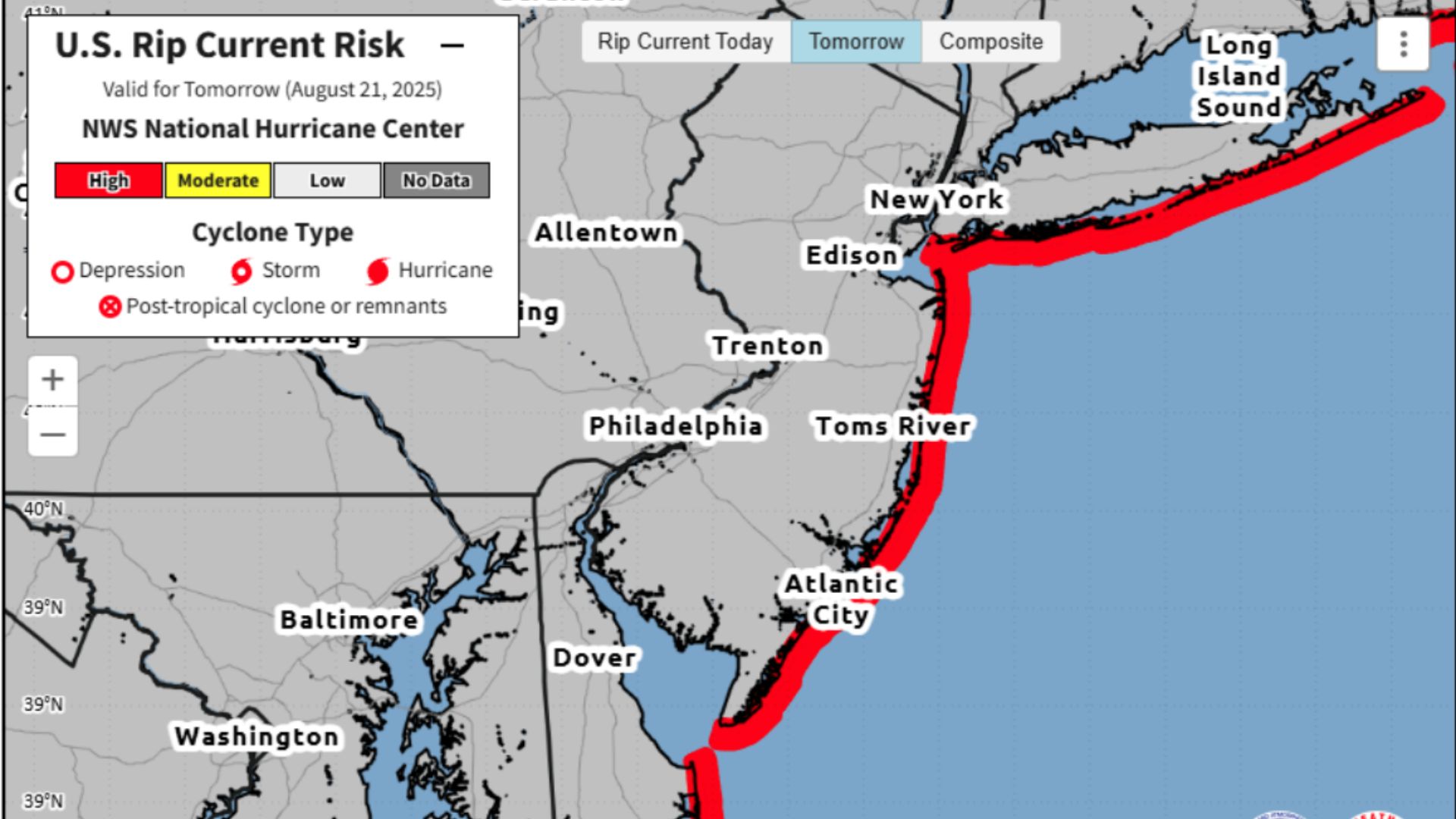
Conditions will remain dangerous on Friday, with waves still reaching 6 to 9 feet. The Weather Service has issued a high rip current risk, warning swimmers to stay out of the water as life-threatening currents are likely along the Jersey Shore and Delaware beaches. Significant beach erosion is also anticipated.
As a reminder, most beach towns have CLOSED their beaches. Don’t be an idiot.
 The greatest concern, however, remains coastal flooding. Moderate to locally major flooding is forecast to affect oceanfront areas, back bays, and tidal waterways during times of high tide, particularly on Thursday evening.
Also See: How Banner Planes Work – Behind the Scenes of Aerial Advertising
Forecasters warn that inundation could cover roads and reach into low-lying structures. Sussex County, Del., is expected to face the most severe impacts, where locally major flooding could occur.
 “Residents should prepare for flooded roads, possible closures, and water entering vulnerable structures near the coast,” the Weather Service said in a statement. “The Thursday evening high tide is expected to bring the highest water levels and the most significant flooding.”
The Delaware Bay and lower coastal waterways are also at risk, with flooding expected to continue through at least Friday evening.
The Chesapeake Bay, by contrast, is not forecast to see significant effects from Erin.
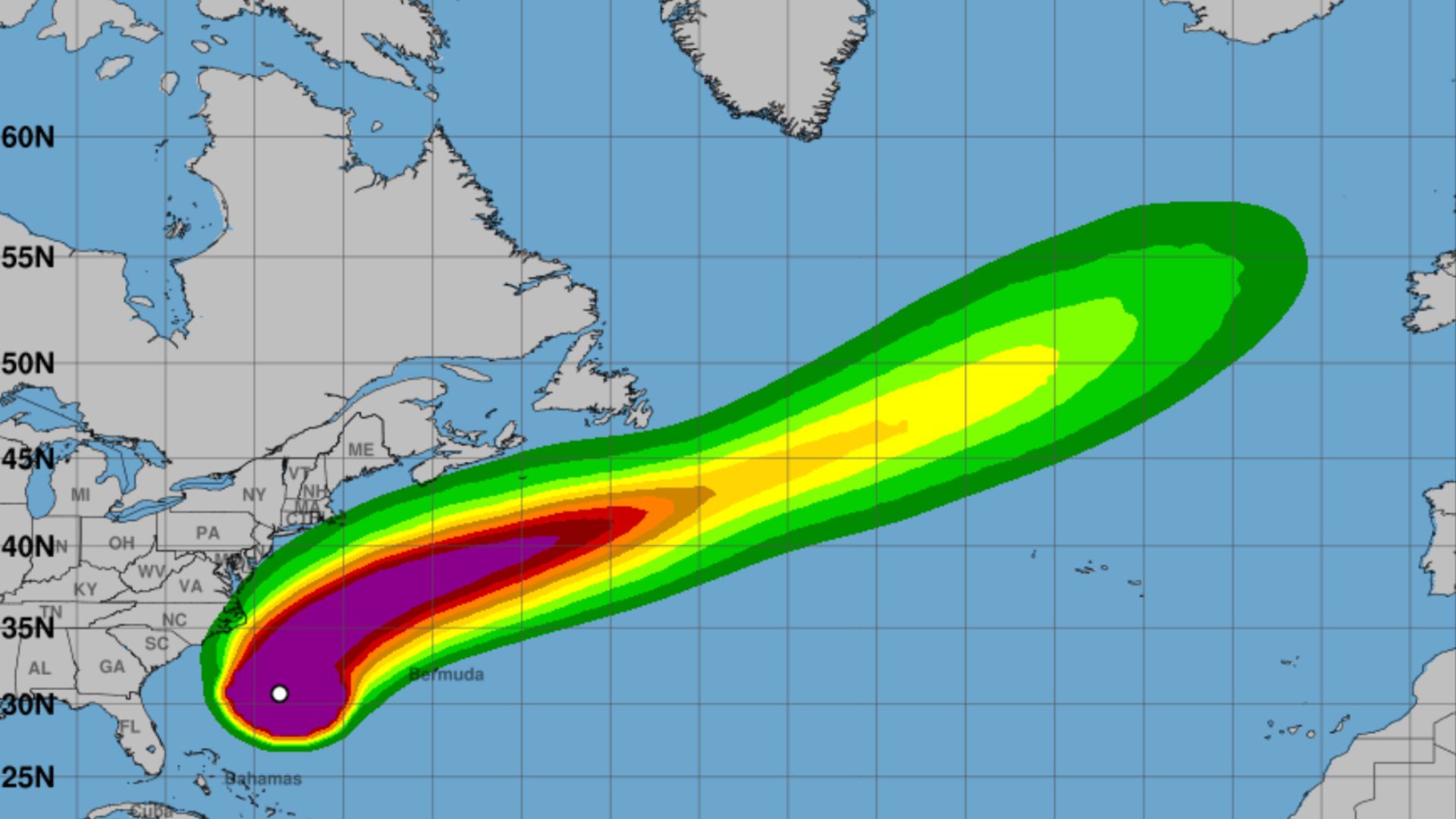
 Mariners are urged to remain in port. Tropical storm-force winds and gale-force gusts are expected to sweep across the Atlantic coastal waters of New Jersey and Delaware, combining with seas over 15 feet to create extremely hazardous conditions. “These are life-threatening seas,” forecasters warned. “Conditions will be dangerous to anyone caught offshore.”
Adding to the hazards, a separate weather system interacting with Erin’s moisture may bring isolated instances of flash flooding inland through Wednesday evening, though forecasters say these risks are more localized.
Hurricane Erin’s path will keep its center offshore, but the storm’s broad reach underscores how far-reaching the effects of tropical systems can be, even when they do not make landfall.
Officials are urging residents along the mid-Atlantic coast to take precautions, avoid unnecessary travel during periods of tidal flooding, and steer clear of beaches and piers until the storm passes.
The Wildwood Video Archive will be reporting from the beaches on Thursday, so be sure to subscribe to our Youtube Channel.