
A Coastal Storm Threatens the Jersey Shore With Flooding and Strong Winds
Forecasters are warning that a developing coastal storm could bring flooding, damaging winds, and dangerous surf to New Jersey and Delaware early next week, marking one of the most serious storm threats of the fall season.
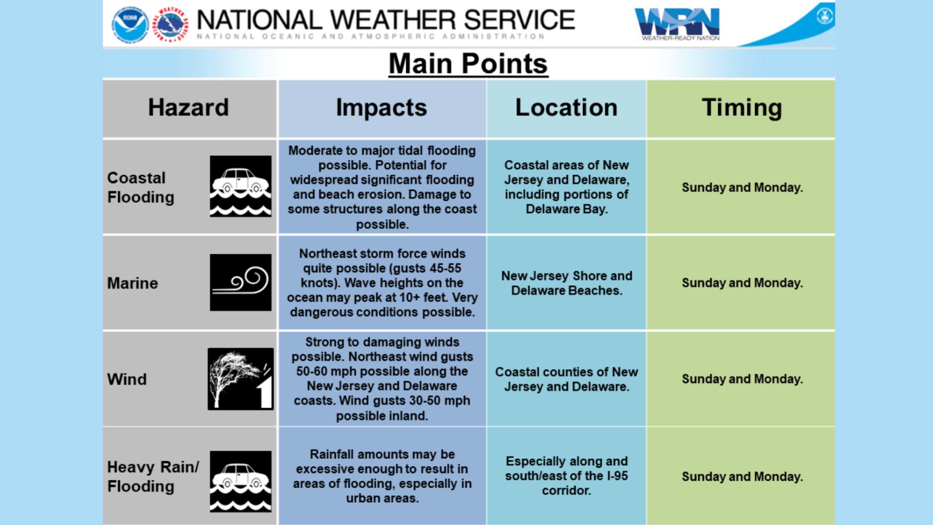
The National Weather Service in Mount Holly said Thursday that the system, expected to arrive Sunday into Monday, could produce moderate to major coastal flooding, beach erosion, and waves exceeding 10 feet along the Atlantic coast and Delaware Bay.
A Coastal Storm Threatens the Jersey Shore With Flooding and Strong Winds
The exact track of the storm remains uncertain, but meteorologists say conditions are aligning for a potentially high-impact event.
“Some data suggest this could be a significant to severe coastal flooding event,” the Weather Service said in its early forecast discussion.
 Flooding and Beach Erosion Expected
The primary concern is tidal flooding, which could inundate low-lying areas, flood coastal roadways, and damage properties close to the shoreline.
The Weather Service warned that the magnitude of the flooding will depend heavily on the storm’s path and wind intensity, though early indicators point toward widespread impacts along the New Jersey and Delaware coasts.
Also See: North Wildwood Boardwalk Reconstruction Officially Underway!
 Coastal communities, including Wildwood, North Wildwood, and Cape May, are being urged to prepare for the possibility of high tides breaching bulkheads and dunes.
Beach erosion is likely, forecasters said, as persistent northeast winds push water toward the coast through multiple tidal cycles.
Winds Could Top 60 Miles Per Hour
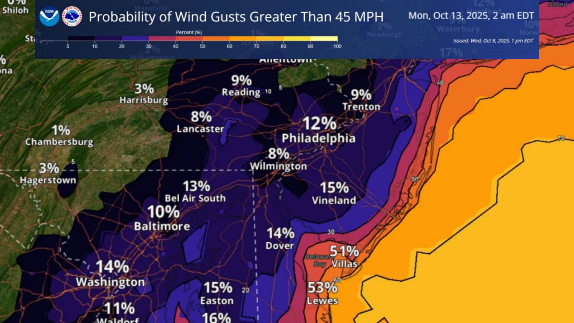
The storm is also expected to produce strong northeast winds, with gusts reaching 50 to 60 miles per hour along the shore and 30 to 50 miles per hour farther inland.
 Such winds could cause power outages, fallen trees, and travel disruptions, particularly across barrier islands and bridges exposed to the open ocean.
The actual magnitude of the winds will depend on the storm track and intensity
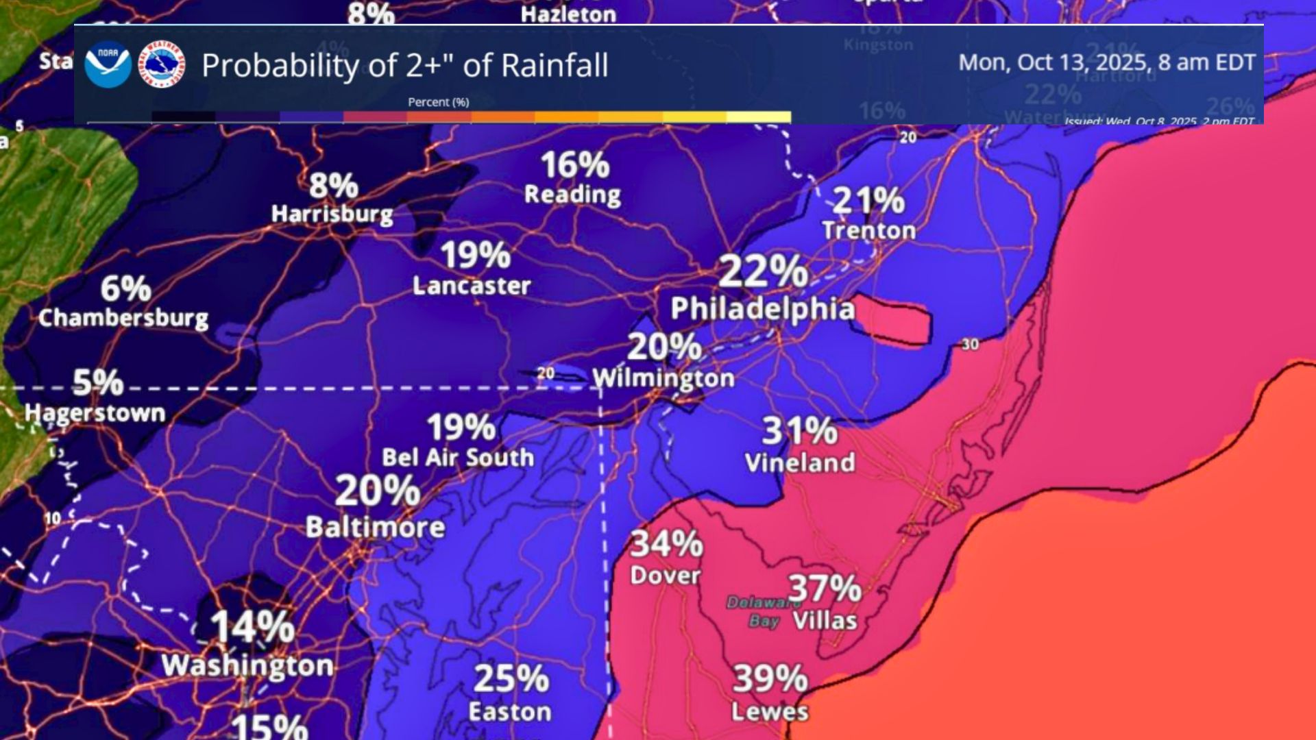
Heavy Rainfall Could Add to Flooding
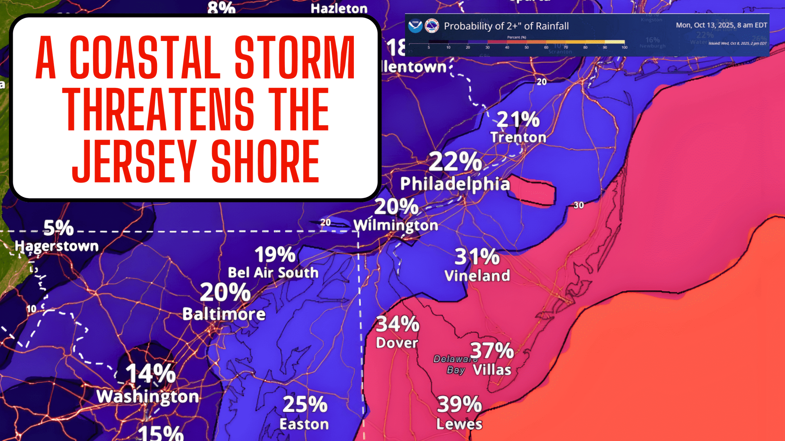
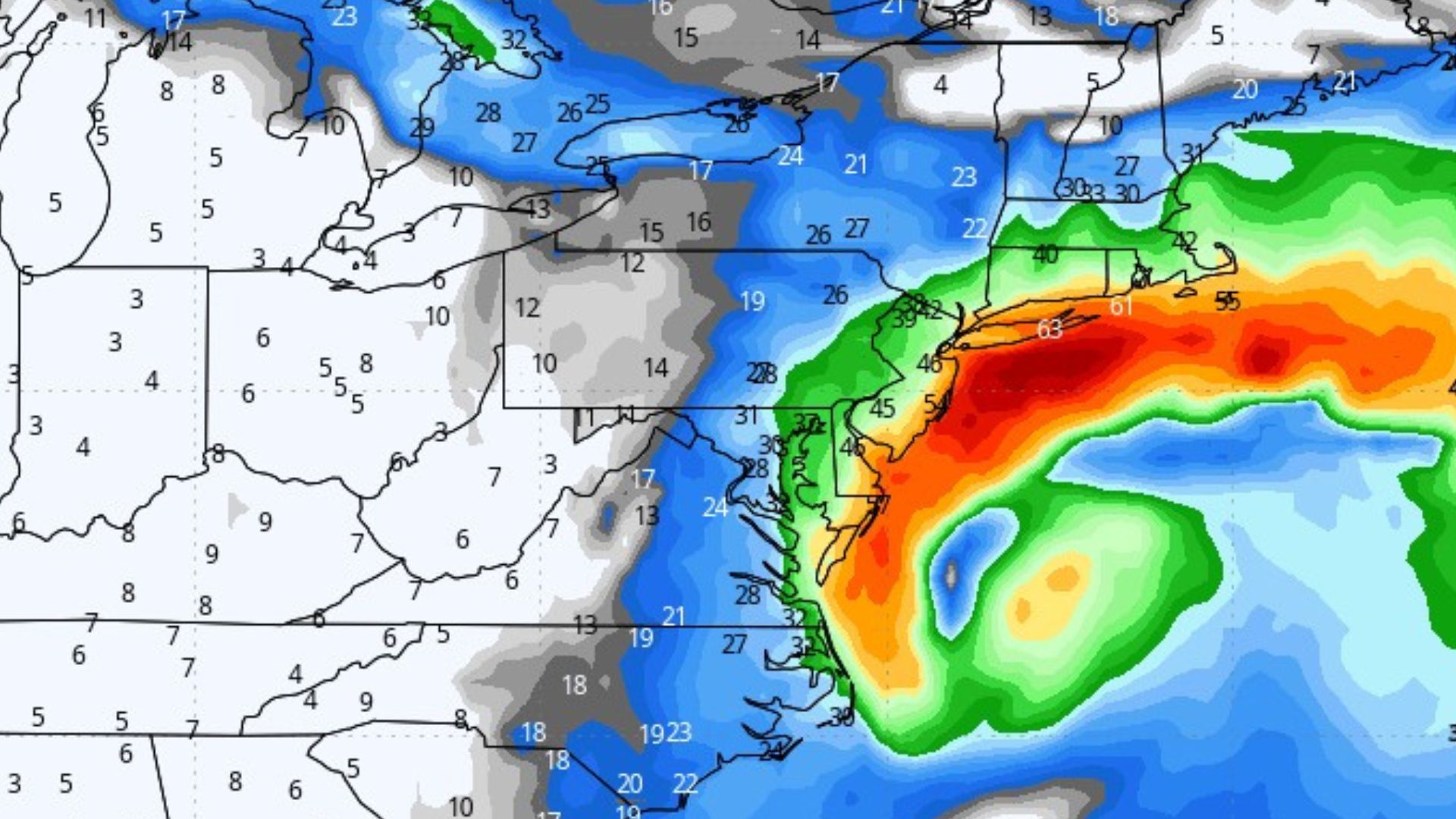
Along with coastal impacts, the Weather Service is tracking a high probability of heavy rainfall, potentially exceeding two inches across much of the region.
Rain could fall heavily at times, raising the risk of urban flooding, especially in areas along and southeast of the I-95 corridor.
 Dangerous Marine Conditions
Mariners are being advised to exercise extreme caution. Storm-force winds are likely offshore, with gusts between 45 and 55 knots and ocean waves peaking above 10 feet, creating very dangerous conditions for small craft and commercial vessels.
Watching the Track
Forecasters caution that uncertainty remains regarding the storm’s final track, which will ultimately determine whether the most severe conditions develop along the coast or remain offshore. Still, confidence is growing that at least some level of coastal flooding and wind damage will occur late this weekend into early next week.
Officials urge residents and visitors to monitor forecasts, secure outdoor items, and avoid coastal roadways during periods of high tide.
The Wildwood Video Archive will continue to follow this developing storm and provide updates as new information becomes available from the National Weather Service.