
Just when you thought that the rain was over and the weather was getting better . . . a serous storm is forecast for late this week into the weekend. Keep an eye on local radio and watch the tide heights starting Thursday. Predicted moderate coastal flooding is a problem for many of us on the west side of town. Still a few days out and things can change but as massive as this storm is we will be getting something. So far no Emergency Manager Briefings from the NWS.
Here is what they posted on their Facebook Page : “
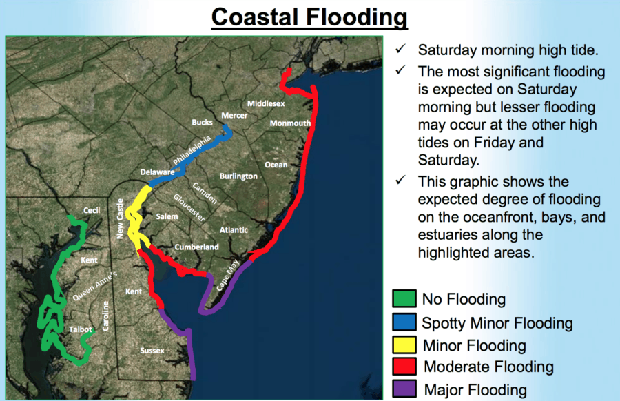 The National Weather Service posted their first briefings for Emergency Managers on their website. They are now using the terms possible moderate to major coastal flooding. A lot will depend on how quick the storm takes to pass our area. While the briefings are great for a look at the NWS’s entire forecast area you have to go to the local forecast discussion for the details for our area.
Here is the tidal flooding portion from the local forecast discussion issuedat 6:35PM for our specific area . . .
TIDES/COASTAL FLOODING…
As the coastal storm strengthens off the coast Thursday night the remains through Saturday, tidal levels will be increasing, and moderate to major coastal flooding becoming more likely for the Saturday morning and Saturday evening high tides, with minor to moderate flooding Friday. We started the Coastal Flood Watch Friday morning since we expect at least minor flooding for all areas along the coast and lower portions of Delaware Bay, and ran it through Saturday evening as the Saturday morning and Saturday evening high tides are expected to be the highest with moderate to major flooding possible. The high tide on Friday evening is not expected to experience any flooding as it is the lower of the two cycles on Friday, plus the flow will not be turning from offshore to back to down-shore until after high tide occurs. However, as we move into Saturday, the flow becomes stronger and down-shore, so the surge component is expected to be onshore again, leading to possible moderate to major coastal flooding along the coast and lower portions of the Delaware Bay.”
Make sure you keep checking back to our page as we will have updates, live streams and other information for you!
The National Weather Service Mt. Holly / Philadelphia Office facebook page is located at https://www.facebook.com/NWSMountHolly/ NWOEM will provide updates on our Facebook Page https://www.facebook.com/NWEmergencyManagement/
https://wildwoodvideoarchive.com/wildwood-spring-sale-going-now/