
State of Emergency Declared as Nor’easter Targets Jersey Shore With Major Flooding
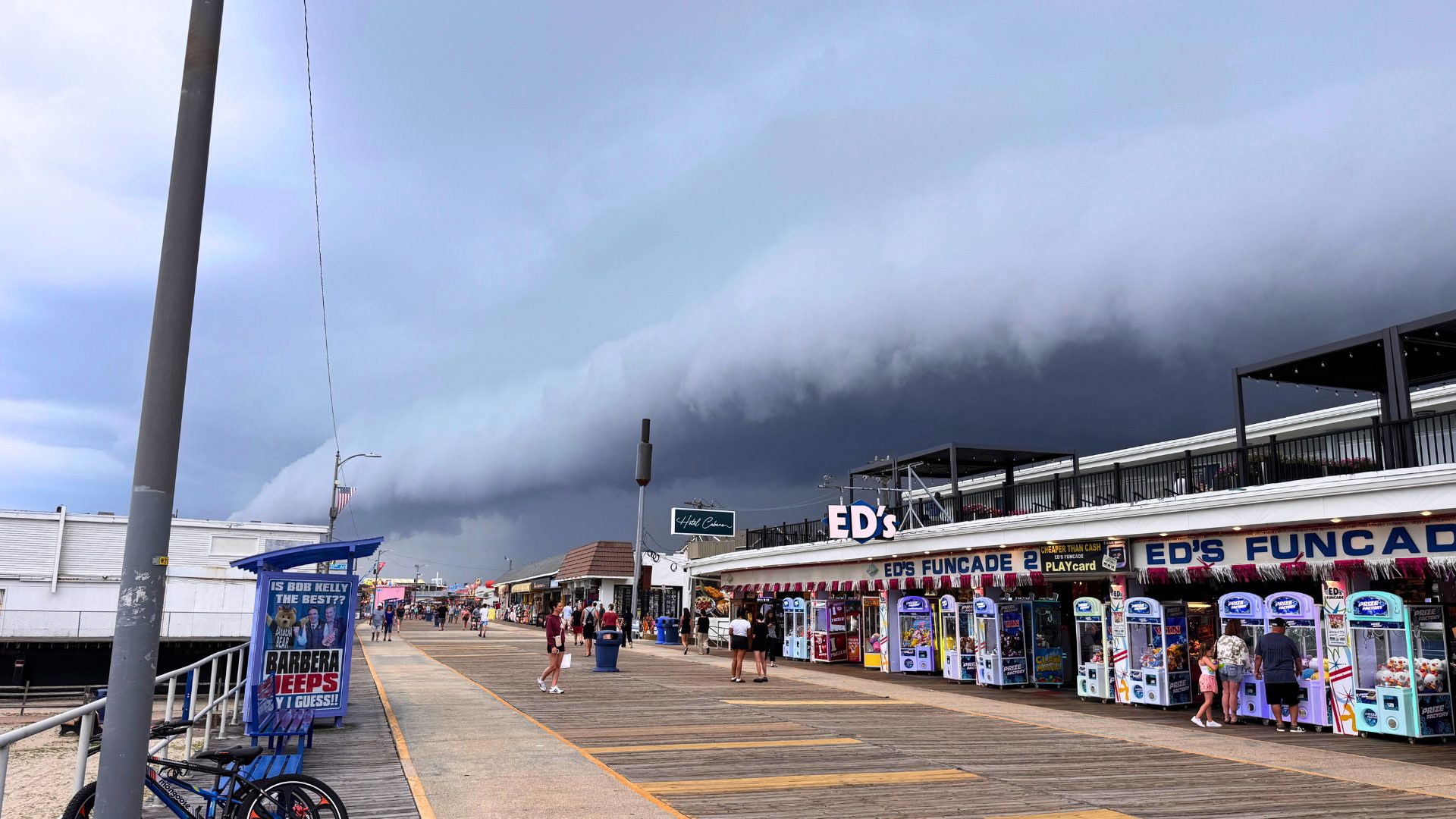
New Jersey is now under a State of Emergency in eight counties as a powerful nor’easter moves into the region, bringing some serious concerns for the Jersey Shore this weekend.
Governor Mikie Sherrill declared the State of Emergency beginning at 5 p.m. Friday, September 25, for Atlantic, Burlington, Cape May, Cumberland, Middlesex, Monmouth, Ocean and Salem counties.
And as we’ve been following this storm over the past few days, the forecast has continued to evolve.
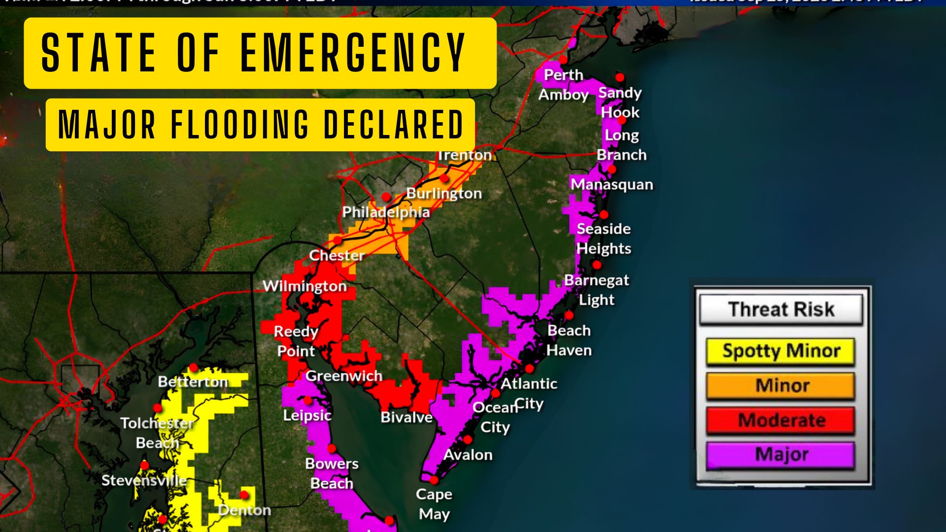
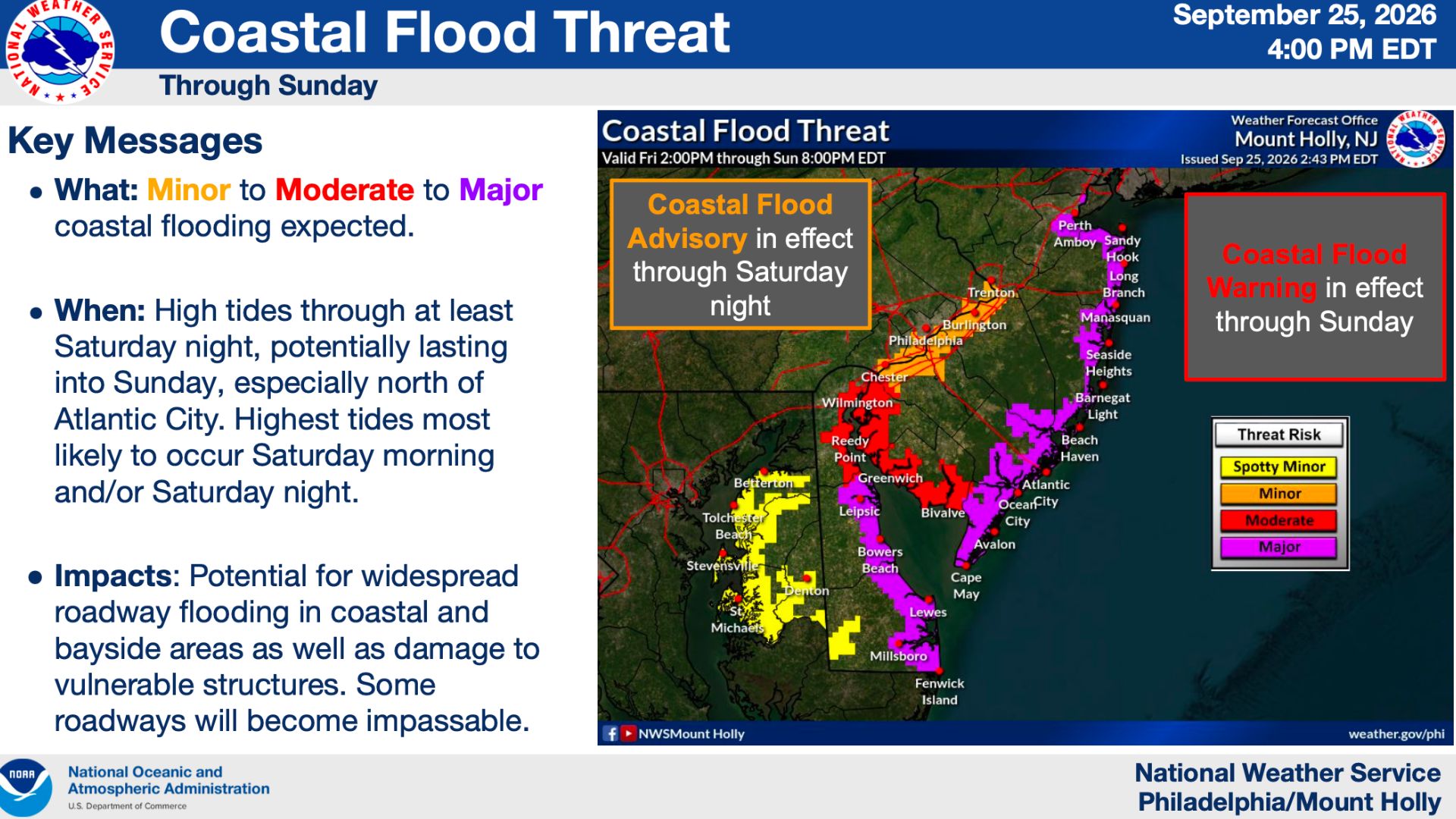
The latest briefing from the National Weather Service in Mount Holly, released at 4 p.m. Friday, now calls for major coastal flooding along portions of the New Jersey Atlantic coast, with the Coastal Flood Warning also expanded to include all areas along Delaware Bay.
For those of us here at the Jersey Shore, flooding is going to be one of the biggest things to watch.
New Jersey Declares State of Emergency as Nor’easter Threatens Major Coastal Flooding
Major Coastal Flooding Expected
The National Weather Service is expecting multiple rounds of coastal flooding through the weekend, ranging from minor to moderate and, in some locations, major flooding.
The highest tides are expected during the Saturday morning and/or Saturday night high-tide cycles. Flooding could potentially continue into Sunday, especially for areas north of Atlantic City.
Also See: The Rook Wildwood Listed for Sale for Nearly $4 Million
And this could be more than the typical flooding we see in some of our usual low-lying areas.
The National Weather Service says there is the potential for widespread roadway flooding in coastal and bayside communities, and some roads could become completely impassable. There is also the potential for damage to vulnerable structures.
So if you live in one of those areas that normally floods during coastal storms, you’ll want to pay especially close attention to the tides over the next 24 to 48 hours.
 Winds Could Reach 60 MPH
Flooding isn’t the only concern.
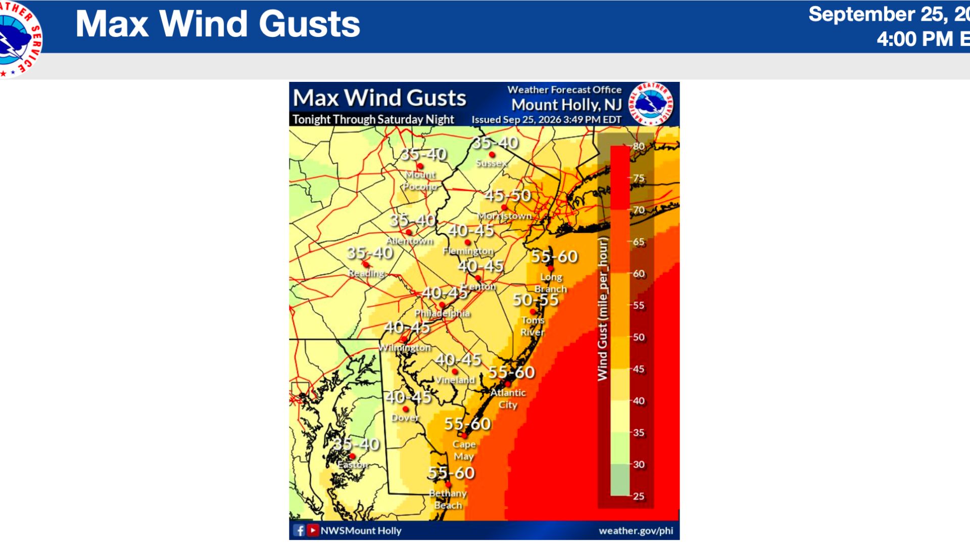
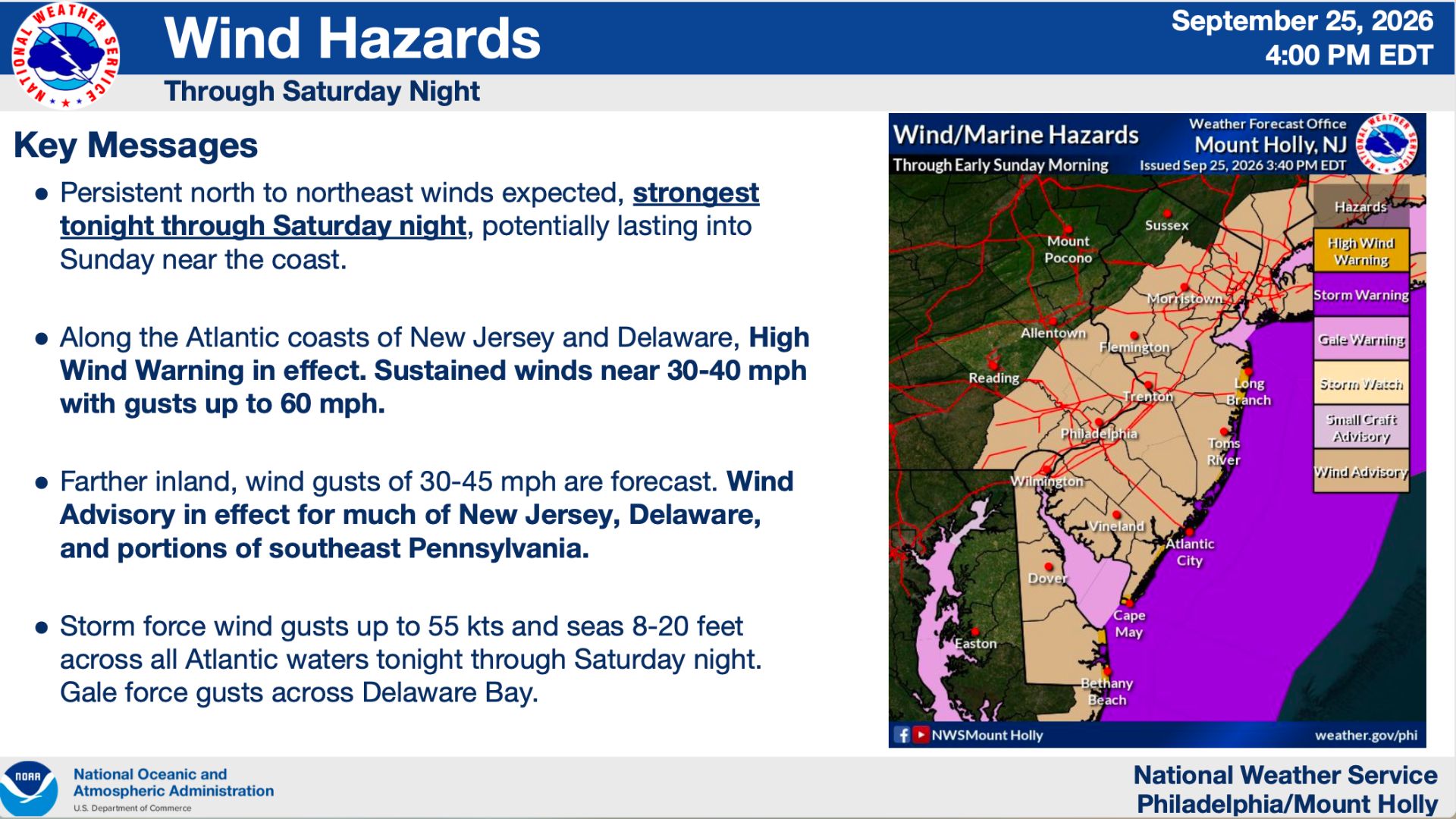
We’re also looking at a prolonged period of strong north to northeast winds, with the strongest winds expected from Friday night through Saturday night.
Along the Atlantic coast of New Jersey, a High Wind Warning is in effect.
The National Weather Service is forecasting sustained winds of 30 to 40 mph with gusts as high as 60 mph along the coast.
Farther inland, winds won’t be quite as strong, but gusts of 30 to 45 mph are still possible across much of the state.
The wind map included in Friday afternoon’s briefing shows potential gusts around 55 to 60 mph along portions of the Cape May County and Atlantic County coastlines.
With winds like that, residents should secure anything outside that could blow around, including patio furniture, trash cans, umbrellas and decorations.
 Beaches Could Take a Beating
Another concern is what this storm could do to our beaches.
The combination of strong onshore winds, rough seas and several high-tide cycles could cause significant beach erosion along the Jersey Shore.
The National Weather Service says there is a high risk of rip currents through Sunday, dangerous surf is expected, and even dune breaches are possible in some locations.
Conditions offshore will also be extremely rough.
Storm-force wind gusts of up to 55 knots are possible over the Atlantic waters, with seas building to between 8 and 20 feet through Saturday night.
 Why Was a State of Emergency Declared?
The State of Emergency doesn’t mean everyone needs to stay home or that businesses automatically have to close.
What it does is allow New Jersey to activate additional resources and better coordinate the state’s response to the storm.
Under Executive Order No. 25, the State Emergency Operations Center has been activated, bringing together agencies including the New Jersey State Police, Department of Environmental Protection, Department of Transportation and county emergency management offices.
“Starting tonight, this nor’easter is expected to bring damaging winds, heavy rain, significant coastal flooding, and resulting beach erosion, with these eight counties facing the greatest risk,” Governor Sherrill said.
She is asking residents to charge their phones, secure loose items outside, have food and water available and avoid unnecessary travel as conditions deteriorate.
And, as always, never drive through a flooded roadway.
 What Happens Sunday?
This is probably the biggest question we still have about this storm.
The National Weather Service says confidence in the forecast is high through Saturday night.
After that, things become much less certain.
A low-pressure system is developing offshore, and exactly where that low goes will determine what happens Sunday. If it tracks close enough to the New Jersey coast, the National Weather Service says significant coastal and marine impacts could continue into Sunday, along with additional rain and wind.
So while we have a pretty good idea of what we’re dealing with through Saturday night, Sunday’s forecast is something we’re going to have to continue watching.