As you may know by now, we could be looking down a major snow storm/Nor’Easter in the coming days.
In yesterday’s update we told you that the storm was still too far out to give a more detailed report but now that we are within 48 hours of it we can start to see the bigger picture.
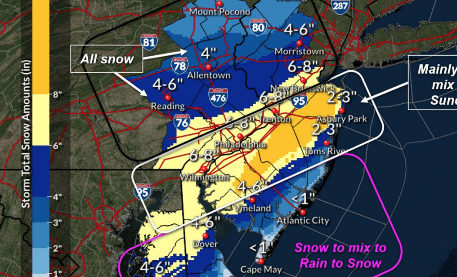
NJ + PA Snow Totals – Nor’Easter Update
According to latest from The National Weather Service in Mount Holly, a winter storm watch will be in effect in the tai-state from Sunday afternoon through late Monday night.
This storm will be ridding the 95 corridor north and for most of the storm this will roughly be the dividing line for major snow totals but the shore will get hit with some moderate flooding.
Flooding
Gale force northeasterly winds will build up the tide by 8 feet on the Atlantic while the Delaware bay will see a 5 foot rise. Looking at the tide charts we see that our beaches could be hit with up to 9 feet. The highest of tides will take place on Monday.
This means that if you live in an area where it normally floods you should move your car.
Winds
The northeasterly wind will reach speeds of 25- 35 mph, with gusts up to 50+ mph along the Atlantic coastline. This wind could create snow drifts in areas with heat snow totals.
Snow
Snow will arrive SW to NE Sunday afternoon with it changing overnight into a Monday morning mix. The coast areas will likely have sleet and rain. The mix away from the shore will change back to snow by late Monday before winding down early Tuesday.
Snow amounts could be significant with the heaviest amounts currently favored south of I-78 to near and just south of I-95 where 6 to upwards of 12 inches will be possible.
However it needs to be stressed that the exact storm track remains uncertain and a shift in this track could bring the heavier snow amounts either farther north or farther south towards the coast with less mixing occurring. The heaviest snow is likely during the day Monday when rates could exceed 1 inch per hour at times in the heaviest bands.
The map shows that Philadelphia could get 6-8 inches of snow while central Jersey could see up to 12 inches. Most of the shore from Tom’s River to Cape May will only have a mix.