Press Release Briefing from the NWS in Mount Holly
The National Weather Service has issued a storm warning for Cape May County from now until 6 am Monday, October 3rd.
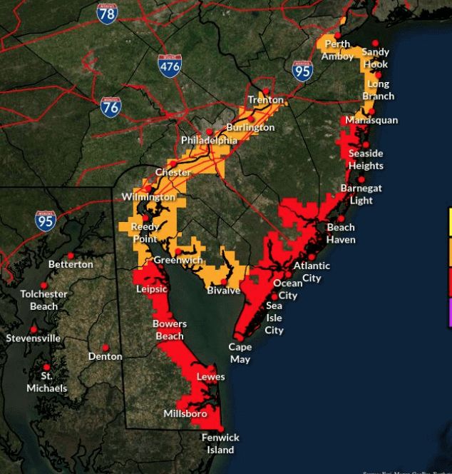
STORM WARNING IN EFFECT for Cape May County
A prolonged period of onshore flow and rain will bring a few different impacts to the region.
Coastal flooding is possible through the first half of the week. The Monday and Tuesday afternoon high tides are expected to have the worst impacts, with moderate flooding possible with that tide cycle for southern Delaware and the central and southern New Jersey coast. Localized major tidal flooding is possible. Impacts may linger longer and be worse on back bays than on the ocean front, especially Sunday and Monday.
Strong onshore flow will result in hazardous conditions for mariners and beachgoers. Dangerously high surf could result in some beach erosion. A high risk of rip currents is expected through at least Monday.
Winds of 45 to 60 mph for portions of southern Delaware and Eastern New Jersey could result in minor tree and wire damage through late tonight. Cape May is projected to have the highest wind topping out at 60mph
Tonight, October 2nd, we will see North-East winds around 34 mph with gusts up to 60 mph. Seas will reach 9 to 14 feet with swells that will last 8 seconds. Additional rain amounts of 1 to 4 inches could cause localized flooding and exacerbate tidal flooding
Very strong winds will cause hazardous seas which could capsize or damage vessels and reduce visibility.
Periods of light to moderate rain are possible through Tuesday. Widespread flooding is not expected, but rain could exacerbate tidal flooding.
Check back later for more updates
[Cover Photo by Tracy Berger]
Check out these other Wildwood videos and articles